What is a smart motorway? Signs and speed limits explained, how to use them and map of where they are in UK
and live on Freeview channel 276
No new smart motorways will be built in the UK after the government announced plans to scrap the controversial roads.
After pausing any new construction in early 2022, the Department for Transport has now said it is abandoning plans for 14 stretches of all-lane running roads across England, including on sections of the M6, M25 and M40. It said financial pressures and a lack of public trust in the roads had led to the decision.
Advertisement
Hide AdAdvertisement
Hide AdIt said it would remove the schemes - three yet to be started and 11 existing projects - from its road building strategy, saving an estimated £1 billion. Two stretches - on the M25 between junctions 21a to 26 of the M6, and between junctions six to eight of the M56 - will still be finished and activated as they are more than 75% complete.
The decision comes after Prime Minister Rishi Sunak pledged to ban the "unsafe" and "unpopular" road system and amid ongoing arguments around their safety.
The DfT, however, made it clear that existing stretches of smart motorway - which make up around 10% of England's motorway network - will remain in place, so it is vital drivers know what they are and how to use them.
What are smart motorways?
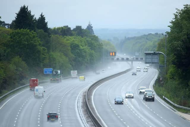
Smart motorways are designed to ease congestion by permitting cars to be driven on the hard shoulder at least some of the time, with traffic being monitored and controlled via cameras and active speed signs which can vary the limit and indicate lane closures.
Advertisement
Hide AdAdvertisement
Hide AdThe idea is that smart motorways effectively add 33 per cent to motorway capacity for much less than it would cost in both financial and environmental terms to add a physical extra lane.


There are currently three types of smart motorway:
Controlled motorway (eg the western section of the M25): variable speed limits monitored via a regional traffic centre. You’re only allowed to use the hard shoulder in an emergency, for example a breakdown.
Dynamic hard shoulder (eg junctions 10-13 on the M1): vehicles can use the hard shoulder at peak times to ease congestion. The traffic control centre will put a speed limit sign on the gantries above the shoulder to indicate it is in use, and a red X above it when it isn’t. If you use a hard shoulder below a red X you’re liable to be fined. Emergency refuge areas (ERAs) are positioned at intervals for vehicle breakdowns. Concerns have been raised that the varying use of the hard shoulder could cause confusion. As a result no more dynamic hard shoulder stretches are being constructed and existing roads are being turned into all lane running
All lane running (eg M6 junctions 16-19): on these motorway stretches, the hard shoulder works as a normal lane all the time. Again, there are ERAs at regular intervals. The hard shoulder lane may be closed if there’s an incident. If this is the case a red X will be displayed above it on gantries
Where are the smart motorways?
Advertisement
Hide AdAdvertisement
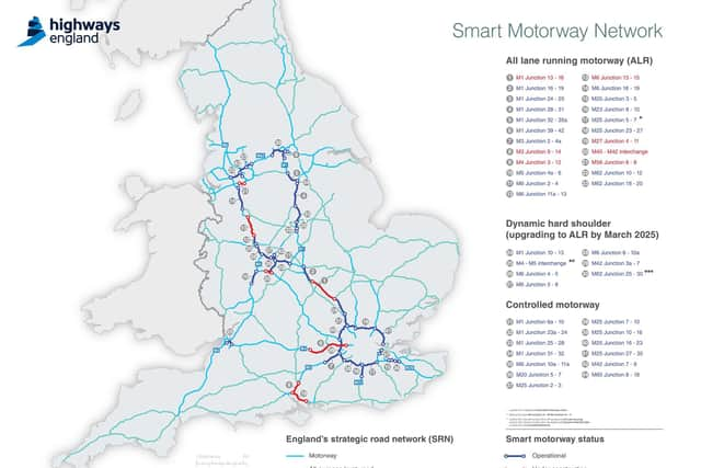
Hide AdThere are currently 44 stretches of smart motorway in operation or under construction, all in England.
Most are concentrated on the M1, M6 and M25 but a total of 14 motorways have some smart motorway element, amounting to around 500 miles of road. The majority of smart motorways are in England’s south-east and around Manchester, Birmingham and Sheffield.
This map from National Highways shows their exact location, including new sections currently under construction.


Emergency refuge areas (ERAs)
Emergency refuge areas replace the hard shoulder on smart motorways.
Advertisement
Hide AdAdvertisement
Hide AdAs the name implies they are intended for use in emergency situations, such as a car developing a fault, where the driver can’t safely get to a service station or other off-ramp.
In most cases, the areas are around 110 feet long, 15 feet wide and the road surface is painted bright orange to make them more visible. An emergency phone connects directly to National Highways.
Currently there can be a gap of up to 1.5 miles between ERAs on all lane running roads, although National Highways is reviewing this with a view to cutting the distance to one mile or less on existing roads and has committed to shorter gaps on all new stretches.
Key rules to obey
ERAs on a smart motorway are strictly only for emergencies. Once you’re stationary in one, you must wait for permission from the authorities before pulling back onto the motorway.
Advertisement
Hide AdAdvertisement
Hide AdDriving in a motorway lane with a red X on the gantry above it is an offence and you will be fined and issued with penalty points.
Smart motorway speed limits, speed cameras and fines
Smart motorways are just like any other road in that ignoring the rules of the road - including speed limits - will see you fined and possibly given penalty points.
All smart motorways are monitored by cameras to track traffic incidents and enforce speed limits, including variable ones displayed on the overhead gantries.
Breaking the variable limit will see you handed a speeding fine but the cameras also operate even when variable limits are not in place. That means if there’s no limit displayed on a gantry you will still be fined if you exceed the national speed limit of 70mph.
Advertisement
Hide AdAdvertisement
Hide AdYou will also be fined for ignoring the red X lane closed signs. As with speeding, this is enforced via gantry cameras and driving in a closed lane will see you fined up to £100 and given three points on your licence.