Flood map: long term UK flood risk maps from Fathom explained - which areas are most at risk of warnings?

and live on Freeview channel 276
According to a study, if nations achieve their globally agreed-upon climate targets, the damage caused by floods in the UK may be significantly decreased. The Association of British Insurers estimates that flood damage currently costs the UK £700 million annually.
Researchers from the University of Bristol and flood modelling firm Fathom assessed the UK’s flood risk using the latest Met Office climate projections.
Advertisement
Hide AdAdvertisement
Hide AdThey found that damage levels can be reined in at just 5% above historical levels, but only if countries around the world honour the pledges they made at the UN climate conference Cop26 in Glasgow.
Countries such as the UK which also made further net zero commitments will have to meet those as well. If not, and the average global temperature reaches 3.3C above pre-industrial levels, the annual cost to properties and businesses could rise by more than a fifth, it found.
Here is everything you need to know about it.
How was the new map created?

The research team from Bristol University and Fathom simulated all sorts of floods in the upcoming decades to develop the new flood risk maps.
They created a precise picture of how much flood damage that could be caused to people’s homes and businesses throughout England, Scotland and Wales using information about the geography, river flow, rainfall patterns, and sea level. This information was integrated with century-long climate projections from the Met Office.
Advertisement
Hide AdAdvertisement
Hide AdAs the temperature warms, the team is also modelling flooding in Northern Ireland in order to broaden the forecasts to cover the entire UK.
Which areas are most likely to be affected?
Professor Paul Bates, lead author of the study and chairman of Fathom, said: “For the first time this flood model gives us a more accurate and detailed picture of the impact of climate change on the risk of flooding in the future across the UK.”
The researchers said existing official maps, used to inform flood defence investment policy and long-term risk planning, lack transparency and are not peer-reviewed.
They described them as “insufficiently validated”, with the methods used to create them “clouded in secrecy” and unrepeatable, while calls for proper peer review of UK national flood risk assessments have gone ignored.
Advertisement
Hide AdAdvertisement
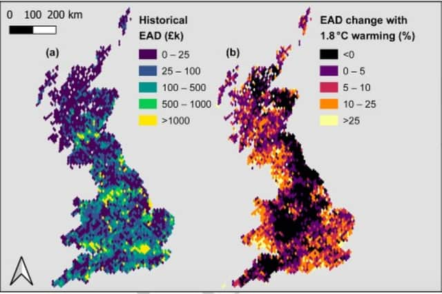
Hide AdThe data also showed regional differences in potential flood damage which hold true even if the average global temperature was limited to 1.8C above pre-industrial levels – slightly above the internationally agreed limit of 1.5C.
South-east England, South Wales, north-west England and central Scotland face the greatest risk, with densely populated cities such as London, Cardiff, Manchester, Glasgow and Edinburgh looking at possible damage increases of more than 25%.
North-east and central England as well as northern Scotland would face around the same level of flood damage as they do today.
Prof Bates said: “We found that flooding increases most in places where risk is already high now, so the best thing we can do to prepare for the impact of climate change is to strengthen flood management in currently at-risk areas, and this will bring immediate economic and social benefits as well.”
Comment Guidelines
National World encourages reader discussion on our stories. User feedback, insights and back-and-forth exchanges add a rich layer of context to reporting. Please review our Community Guidelines before commenting.