Snow forecast: Met Office weather maps show where and when big freeze will hit the UK this week

and live on Freeview channel 276
Snow is on its way to the UK this week, as temperatures begin to drop in some areas.
The cold snap, which will bring temperatures down to freezing in some northern areas, is due to sweep in later this week. And it will bring with it the chance of snow in some places. The Met Office deputy chief meteorologist Chris Almond said: “There’s an increased signal for wintry hazards as we move through the week as cold air from the north moves over the UK."
Advertisement
Hide AdAdvertisement
Hide AdSmall patches of snow and hail have already been experienced in northern parts of Scotland, as well as in some areas of Northern Ireland on Tuesday, February 6. Forecast maps from the Met Office show that into the late afternoon and early evening, snow and hail will gradually easy in Scotland, but some areas in North Wales and the Midlands may experience hail from around 3.30pm through to around 1.30am on Wednesday morning (February 7).
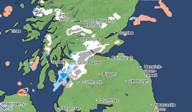

At around the same time, snow will return to northern areas of mainland Scotland, while snow and hail will periodically move over Shetland Islands. Moving south, snow will reach the west coast of Scotland, reaching Glasgow at around 7am on Wednesday morning and moving eastwards to Edinburgh by 9am.
After a flurry in Scotland in the morning, most of Wednesday will remain mostly clear. However, a weather front will move in from the south from around midnight, bringing snow to North Wales by 5am on Thursday morning (February 8). It will spread eastwards throughout the morning, with snow and hail reaching Sheffield, Manchester and Nottingham by 9am.

Almond added: "It’s from Thursday that the snow risk becomes potentially impactful, as mild air attempts to move back in from the south, bumping into the cold air and increasing the chance of snow where the two systems meet. While there are still lots of details to work out, the initial snow risk looks highest in northern England and Wales from Thursday.”
Advertisement
Hide AdAdvertisement
Hide AdThroughout Thursday afternoon, the snow will spread north to areas such as Kendall and Leeds by 3pm. Into Friday morning (February 9), a band of snow and hail will travel northward across the UK, moving up into Scotland from northern England.
Much of northern Scotland will be covered by snow by Saturday (February 10) at midnight. However, the cold front will likely move away from the UK by Sunday February 11.
Comment Guidelines
National World encourages reader discussion on our stories. User feedback, insights and back-and-forth exchanges add a rich layer of context to reporting. Please review our Community Guidelines before commenting.