Storm Jocelyn: Met Office issues weather warnings - where and when will rain and wind hit?

and live on Freeview channel 276
One storm has been replaced with another as Storm Jocelyn prepares to sweep across the UK, just days after Storm Isha brought strong winds and rain.
Storm Jocelyn is due to hit the UK on Tuesday evening (January 23) into Wednesday (January 24). The storm will bring with it more of the same dreary weather, with high winds and rain forecast for some areas of the country.
Advertisement
Hide AdAdvertisement
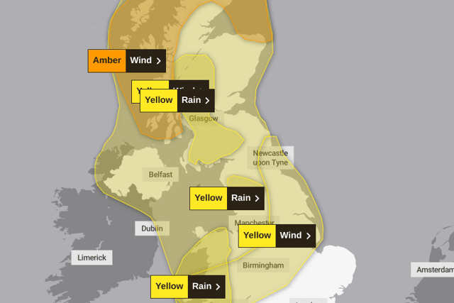
Hide AdThe Met Office has issued a new weather warning for rain for most of Wales, in place from 12.30pm until 7pm on Tuesday. Other weather warnings relating to Storm Jocelyn include:
- Amber wind warning - northern and western coasts of Scotland, from 6pm Tuesday until 8am Wednesday
- Yellow wind warning - Scotland, Northern Ireland, Wales, north-west England, from 4pm Tuesday until 1pm Wednesday
- Yellow wind warning - north-east coast of England stretching to the Midlands, from 12pm Tuesday until 3pm Wednesday
- Yellow rain warning - west coast of Scotland including Glasgow, from 7am Tuesday until 6pm Tuesday
- Yellow rain warning - north-west England including Kendall, from 11am Tuesday until 7pm

Jocelyn is set to touch down on northern Scotland on Tuesday evening, before moving further south, to the rest of Scotland, Northern Ireland and northern parts of England. Met Office Chief Meteorologist, Steve Willington, said: “Although this system will be a step down relative to Storm Isha, with the damage and clean up still underway, we could potentially see more impacts from Storm Jocelyn.
He added: “Outbreaks of heavy rain on Tuesday could bring rainfall accumulations of 15 to 20 mm quite widely with 40 to 50 mm over higher ground in southwest Scotland, the Scottish Highlands and parts of northwest England. Wind gusts are expected to reach 55 to 65 mph across northwestern Scotland while there is potential for winds to gust to 75 to 80 mph in a few places, in particular exposed parts of the Western Isles and coastal northwest Scotland early on Wednesday morning.”
Comment Guidelines
National World encourages reader discussion on our stories. User feedback, insights and back-and-forth exchanges add a rich layer of context to reporting. Please review our Community Guidelines before commenting.