Storm Kathleen to blast UK with hottest day of the 2024 today... and 70mph winds - weather warnings in place

and live on Freeview channel 276
Saturday (6 April) has provisionally become the hottest day of the year so far with 20.9C recorded, the Met Office said. The highest temperature was reached in Santon Downham, Suffolk, on Saturday afternoon.
Storm Kathleen was expected to pummel the UK with warm air from the continent this weekend, bringing with it the hottest day of the year so far - as well as strong winds.
Advertisement
Hide AdAdvertisement
Hide AdIt was forecast that East Anglia could see temperatures as high as 22C on Saturday (6 April), according to the Met Office, while gusts of up to 70 mph were predicted for western regions of the country.
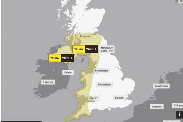
A yellow weather warning has been issued by the forecaster for wind on Saturday from 8am to 10pm in the north and south west of England, as well as in some areas of Northern Ireland, Scotland and Wales.
Met Office meteorologist Ellie Glaisyer told the PA news agency: “The storm is the reason we are seeing the warmer temperatures, because the location of the storm – situated out towards the west of the UK – is bringing a southerly wind across the UK.
“This is bringing those warmer temperatures from the continent, meaning we are likely to see temperatures reaching 22C.”
Advertisement
Hide AdAdvertisement
Hide AdThe highest temperature of the year so far was 19.9C, recorded at the end of January at Achfary in north-west Scotland.
“Storm Kathleen is likely to bring some heavy rain across the UK overnight, which will spread its way northwards across the country,” Glaisyer said, adding: “For most places it should be a relatively dry start to Saturday.”
Where are weather warnings in place?

Storm Kathleen is also expected to bring 50-60mph winds quite widely on Saturday, while some Irish Sea coastal regions will see gusts up to 70mph and large waves.
Glaisyer said: “Almost anywhere is going to see above average temperatures. Western parts of the UK are likely to see temperatures of 15 or 16C.
Advertisement
Hide AdAdvertisement
Hide Ad“However, the further west you are, where those strongest winds are in that yellow warning area, despite the temperatures being above average it will feel a little colder.”
On Friday, the Met Office updated its weather warning to forecast stronger gusts during Storm Kathleen than previously predicted.
It warned of injuries and danger to life from “large waves and beach material being thrown onto sea fronts, coastal roads and properties”, a possibility that “road, rail, air and ferry services may be affected” and the potential for power cuts and phone service outages.
Advertisement
Hide AdAdvertisement
Hide AdThe forecaster said winds would stay strong into Sunday, particularly in northern parts of Scotland.
“There will still be some showers around, but there should be some sunshine between those showers”, Glaisyer said, adding: “It is generally remaining unsettled through much of next week.
“There is another area of low pressure moving towards the UK through Monday and into Tuesday. That is likely to bring some heavy rain for much of the UK, particularly in the West.
Storm Kathleen, named by the Irish meteorological service Met Eireann, is the 11th named storm in eight months. It is only the second time in a UK storm season that the letter K has been reached in the alphabet.
Advertisement
Hide AdAdvertisement
Hide AdThe Met Office’s shipping forecast had 20 gale warnings in place on Friday evening for sea areas including Viking, Plymouth, Biscay, Sole, and Lundy.
The Environment Agency (EA) issued 14 flood warnings – where flooding is “expected” – and 123 flood alerts in England on Friday, with National Resources Wales issuing four flood alerts.
The Environment Agency also issued 43 red cautions for strong streams on the River Thames, advising users of all boats not to navigate.
RAC Breakdown spokesman Rod Dennis said: “This intense period of stormy weather is going to prove extremely challenging for anyone driving on the western side of the UK. We strongly urge drivers to avoid exposed coasts and higher routes where the impact of the very strong winds is most likely to be felt.”
What disruption has Storm Kathleen caused?
Advertisement
Hide AdAdvertisement
Hide AdThousands of customers have been left without electricity as Storm Kathleen continues to sweep across the island of Ireland, with power outages reported on Saturday morning concentrated in the south and west of the country.
And about 70 flights departing and arriving at UK airports before midday on Saturday have already been cancelled. P&O Ferries has also cancelled the sailings between Larne in Northern Ireland and Cairnryan in Scotland until 4pm on Saturday due to the storm.
Meanwhile, Saturday evening’s EPCR Challenge Cup rugby match between Edinburgh Rugby and Aviron Bayonnais has been moved to Scottish Gas Murrayfield from Hive Stadium due to the strong winds expected.
Comment Guidelines
National World encourages reader discussion on our stories. User feedback, insights and back-and-forth exchanges add a rich layer of context to reporting. Please review our Community Guidelines before commenting.