Roman Empire: declassified spy satellite images reveal 400 forts found in the Middle East


Forts from the Roman empire have been found around modern-day Syria, Iraq and nearby regions of the eastern Mediterranean after images were released of the CIA’s Corona and Hexagon reconnaissance missions during the 1960s and 1970s.
In total, the team found 396 forts, adding to the 116 discovered during pioneering aerial surveys of the region in the 1920s by French archaeologist Antoine Poidebard.
Advertisement
Hide AdAdvertisement
Hide AdPreviously it was theorised that the forts were in a mainly a north-south pattern suggesting that they were built as defence measures against the empire’s rival superpowers, the Parthians and the Sasanians - and this reasoning had been widely accepted for decades, with the researchers assuming the purpose of the forts was primarily for military purposes, to strengthen the Roman border.
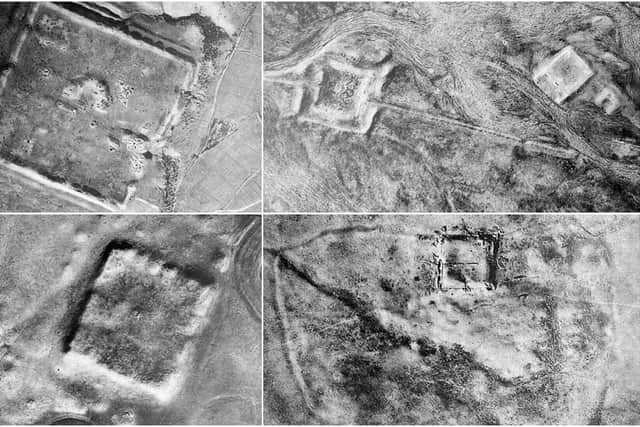
However, Poidebard flew where he thought the forts would be found rather than scanning the entire region, and the latest images show the forts are scattered across the area, with no clear direction or particular lining up of the constructions - and therefore created for a different purpose.
In the journal Antiquity, the authors said: "The addition of these forts questions Poidebard’s defensive frontier thesis and suggests instead that the structures played a role in facilitating the movement of people and goods across the Syrian steppe."
Selling goods and trading was a successful way of maintaining territory, as the forts helped move supplies as well as soldiers around. However, some of the forts predate the empire, having been built in the late Iron Age (750 BCE), but recent excavations suggest most were built and used between the second and sixth centuries AD.
Advertisement
Hide AdAdvertisement
Hide AdThe authors note they also show "a landscape that has been severely impacted by modern-day land-use changes, including urban expansion, agricultural intensification and reservoir construction."
Speaking to Space.com, lead author Jesse Casana said: "The real value in historical, high-resolution imagery like Corona and Hexagon is in preserving a picture of a landscape that by and large no longer exists. Our study also helps show that an unknown number of other sites were also likely lost in the time between Poidebard’s flights in the 1920s and the Corona imagery of the late 1960s."
Comment Guidelines
National World encourages reader discussion on our stories. User feedback, insights and back-and-forth exchanges add a rich layer of context to reporting. Please review our Community Guidelines before commenting.