Roman road network is mapped out after discovery in Britain sheds new importance on small Devon town


The discovery of a mapped-out Roman road network in the UK is shedding new light on southwest England. Researchers have been able to map out a network of roads based on remains that have been found and using technology to identify lost sections of road.
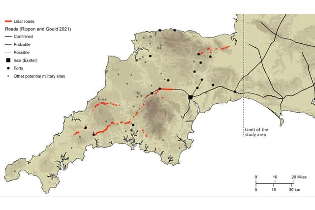
The findings have also revealed how Exeter was far from the main nerve of this network, and the small Devon town of North Tawton was of more strategic importance with its connections such as the tidal estuaries north and south of Bodmin and Dartmoor.
Advertisement
Hide AdAdvertisement
Hide AdThe road connected significant settlements with military forts across the two counties as well as the wider area in the southwest.
Archaeologists at the University of Exeter used laser scans collected as part of the Environment Agency’s National LiDAR Programme to identify new sections of road west of the previously understood boundary.
Using sophisticated techniques, which incorporate information about gradients and flood risk, the researchers have then been able to map out the full extent of the network and begin to understand the rationale for its existence.
The research was led by Dr Christopher Smart and Dr Joao Fonte, specialists in landscape archaeology and the heritage of the Roman Empire, in Exeter’s Department of Archaeology and History.
Advertisement
Hide AdAdvertisement
Hide AdDr Smart said: “Despite more than 70 years of scholarship, published maps of the Roman road network in southern Britain have remained largely unchanged and all are consistent in showing that west of Exeter, Roman Isca, there was little solid evidence for a system of long-distance roads.”
“But the recent availability of seamless LiDAR coverage for Britain has provided the means to transform our understanding of the Roman road network that developed within the province, and nowhere more so than in the far southwestern counties, in the territory of the Dumnonii.”
The National LiDAR Programme was conducted between 2016 and 2022 by the Environment Agency covering the whole of England.
The Exeter team studied the scans and together they were able to map around 100km of additional roads.
Advertisement
Hide AdAdvertisement
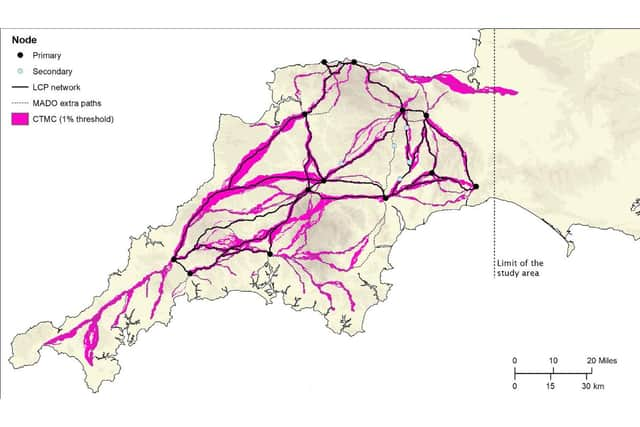
Hide AdAlthough this represented a significant advancement, the overall picture remained fragmented and patchy, with large portions of the map showing no evidence of Roman roads.
The team developed a geographic information system predictive model, which could intelligently fill in the gaps as to the likely layout of the network.
They plotted primary and secondary “nodes” across the two counties, which included permanent military fortifications, including the known forts of Old Burrow and The Beacon at Martinhoe, as well as the settlements at Exeter and North Tawton. They then calculated the easiest routes between these points.
And when the team returned to the LiDAR scans, they were able to identify a further 13km of Roman road within a short distance predicted by the model.
Advertisement
Hide AdAdvertisement
Hide AdThe final stage saw the researchers use focal mobility networks and transit corridors to extend the road network to areas that lay beyond the main Roman sites known in the region.
Dr Fonte added: “In terms of chronology, it is likely that the proposed network is an amalgam of pre-existing Prehistoric routeways, Roman military campaign roads or ‘tactical roads’ formally adopted into the provincial communications system, and of those constructed during peacetime in a wholly civilian context.”
Comment Guidelines
National World encourages reader discussion on our stories. User feedback, insights and back-and-forth exchanges add a rich layer of context to reporting. Please review our Community Guidelines before commenting.