Yorkshire Marathon 2021: route and map for event, York road closures and how to track runners using App


The Yorkshire marathon is now one of the North East’s biggest sporting events, attracting runners from all over the world.
Since it began in 2013, tens of thousands of participants have run, walked and jogged across the finish line while spectators line the streets to cheer them on.
Advertisement
Hide AdAdvertisement
Hide AdThis year is expected to be no different, with runners expected to get into the Yorkshire spirit and “do the Y” as they cross the finish line.
So, when is the annual event and how will it affect roads on the route? This is what you need to know ahead of raceday.
When is the Yorkshire Marathon?
The Yorkshire Marathon takes place on Sunday 17 October, the main event gets underway from 9.30am at York University.
From 7am, baggage drops; the race office and assembly areas will open to participants. Both the baggage store and race event office are located in the event village at York University.
Advertisement
Hide AdAdvertisement
Hide AdDrop off points for runners are at two designated locations:
West Loop: A19 / Main Street (Fulford)- Broadway - Heslington Lane; for participants travelling from the city centre and/or west of the city.
East Loop: Church Lane- Innovation Way - University Road - Field Lane; for participants travelling from the A64 and/or east of the city.
Runners and wheelchair users will be invited to join in the mass warm up at 9.10am, shortly before the race begins.
Advertisement
Hide AdAdvertisement
Hide AdAt 9.25am the wheelchair event begins and just five minutes later, runners will pass the startline.
What is the route?
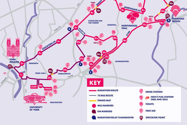
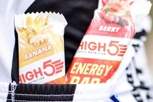
The 26.2 mile route will begin and end at York University, where runners will have access to hydration and food stations, toilets, first aid and baggage stores.
The map shows runners passing York Minster shortly after mile two, spectators can also catch a glimpse of the runners at this point.
From there, participants will pass through Stockton Lane and the village of Stockton on the Forest. The race then veers to the right, up Northgate Lane and mile 11 is reached at the edge of Buttercrambe Moor Wood.
Advertisement
Hide AdAdvertisement
Hide AdParticipants will then head down the outside of Buttercrambe Moor Wood towards Stamford Bridge, at which stage 14 miles will have been completed. Spectators can also get a good view of the event from this point.

Heading into the final 12 miles, runners will head back down towards the university, running along the A166 on the edge of Dunnington.
Runners will head back along the road, towards Warthill, before turning towards Holby Lane.
The final four miles are spent running through Osbaldwick, finishing at York University.
Road closures for Yorkshire Marathon
Advertisement
Hide AdAdvertisement
Hide AdWhile the marathon is an exciting and welcome event in the city of York, it will also cause issues for anyone heading into the town centre on Sunday.
The following road closures will apply during the given times on 17 October:
University Road - from 10am (October 16) to 9pm (October 17)
A166, Church Balk - from 6am to 4pm
Church Street - from 6am to 4pm
Eastfield Lane - from 6am to 4pm
Stockhill Close - from 6am to 4pm
Green Dykes Lane - from 6am to 6pm
Heslington Lane - from 6am to 6pm
Main Street (Heslington) - from 6am to 6pm
A1079 Hull Road (west of Melrosegate) - from 8am to 11:45am
A1079 Lawrence Street, Barbican Road - from 8am to 11:45am
Blake Street, Davygate, Deangate - from 8am to 11:45am
Duncombe Place - from 8am to 11:45am
Foss Bank - from 8am to 11:45am
Foss Island Road - from 8am to 11:45am
George Street - from 8am to 11:45am
Goodramgate - from 8am to 11:45am
Hope Street - from 8am to 11:45am
Jewbury - from 8am to 11:45am
Lead Mill Lane - from 8am to 11:45am
Lord Mayor’s Walk - from 8am to 11:45am
Melrosegate - from 8am to 11:45am
Minster Yard - from 8am to 11:45am
Monkgate - from 8am to 11:45am
Parliament Street - from 8am to 11:45am
Piccadilly - from 8am to 11:45am
St Maurice’s Road - from 8am to 11:45am
Walmgate - from 8am to 11:45am
A1036 Heworth Green - from 8:30am to 12:30pm
Hopgrove Lane South - from 8:30am to 12:30pm
Sandy Lane - from 8:30am to 12:30pm
Stockton Lane - from 8:30am to 12:30pm
The Village (Stockton on the Forest) - from 8:30am to 12:30pm
Common Lane - from 9:15am to 1:15pm
Main Street (Sand Hutton) - from 9:15am to 1:15pm
Northgate Lane - from 9:15am to 1:15pm
Upper Helmsley - from 9:15am to 1:15pm
Buttercrambe Moor Wood to A166 - from 9:15am to 2:15pm
Holtby Lane - from 9:30am to 4:30pm
Rudcarr Lane - from 9:30am to 4:30pm
Straight Lane - from 9:30am to 4:30pm
Bad Bargain Lane - from 9:30am to 4:45pm
Moor Lane - from 9:30am to 4:45pm
Sandy Lane (Murton) - from 9:30am to 4:45pm
Advertisement
Hide AdAdvertisement
Hide AdA1079 Hull Road (east of Melrosegate) - from 9:30am to 5:30pm
Murton Way - from 9:30am to 5:30pm
Osbaldwick Lane - from 9:30am to 5:30pm
Osbaldwick Village - from 9:30am to 5:30pm
Tang Hall Lane - from 9:30am to 5:30pm
Parking suspensions will also be in place in the following areas between 4pm on October 16 and 6pm October 17.
A166 Stamford Bridge / A166 The Square / Church Road / Moor Road
B1228 Elvington Lane
Broadway / Heslington Lane
Common Lane (Elvington)
Common Lane (Stockton on the Forest)
Dauby Lane
Eastfield Lane / Church Balk / Church Street / York Road / York Street / Common Lane (Dunnington)
Green Dykes Lane
Heslington Lane / Main Street (Heslington) / Field Lane
Heslington Road (between A19 Cemetery Road and Wellington Street)
Advertisement
Hide AdAdvertisement
Hide AdHeslington Road (between Belle Vue Terrace and Fairfax House, westbound only)
Holtby Lane
Hopgrove Lane South
Melrosegate
Murton Lane
Osbaldwick Lane / Osbaldwick Village
Sand Hutton
Stockton Lane
University Road / Innovation Way / Church Lane / Field Lane
Thief Lane
Walmgate / Hope Street / George Street / Leadmill Lane
How to track runners during Yorkshire Marathon
If you are heading into the city to cheer on a participant, or just interested in famous runners taking part in the event, you might want to download the Yorkshire Marathon App.
Simply go to the App Store or Google Play to download it free of charge.
You can then search by surnames or running number and follow the runners as they make their way around the course - updates will appear as they cross the timing mats; which are located at 10k intervals and the half way point.
Find your race time and buy marathon pictures
To find out your results and access official event photographs, visit the Yorkshire Marathon website post event.
Comment Guidelines
National World encourages reader discussion on our stories. User feedback, insights and back-and-forth exchanges add a rich layer of context to reporting. Please review our Community Guidelines before commenting.