
Storm Bert: Weather maps show worst-hit areas as Met Office issue weather warnings ahead of weekend


The UK is bracing for Storm Bert this weekend, as it prepares to bring rain, snow and icy winds to the UK.
In a week which has seen snow and ice, as well as tumbling temperatures, hit large parts of the country, it seems as though there will be little reprieve heading into the weekend. The Met Office named its second storm of the season - Storm Bert - yesterday, with warnings that the worst of the weather is still to come for some.
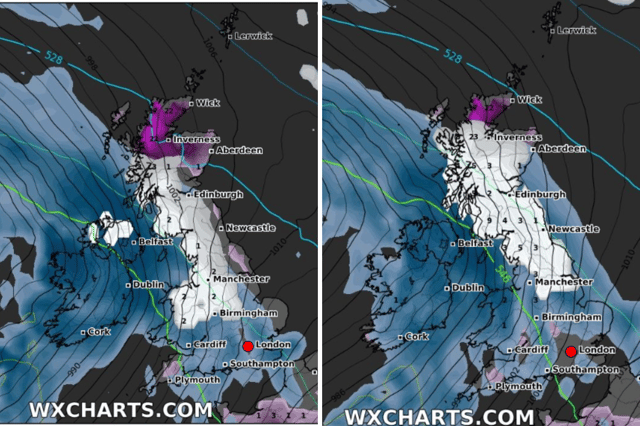
New weather charts from WXCharts has shown where rain, wind and snow will be strongest across the UK. From midnight on Saturday morning (November 23), snow will fall in northern Scotland, Northern Ireland, in patches in southern Scotland, and across Wales and parts of the west Midlands and the north-west of England.
As we move into Saturday morning, snow will blanket more places from 6am. Snow is likely to fall from central and North Wales, stretching up through the west Midlands, the north-west and into Scotland. Most of Scotland will be affected by snow, with northern parts such as Inverness set for the heaviest fall. There will be rain in the south of England, as well as across south Wales.

Snowfall will begin to thaw northwards throughout the morning, with rain replacing the flurries in Wales and the west Midlands. Snow will persist in parts of Scotland, moving eastwards into the evening. Most of Scotland will continue to experience snow on Sunday (November 24), while rain is expected to fall elsewhere.
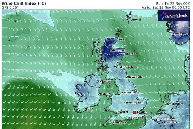
As for winds, the chilliest is set to be felt in northern Scotland at midnight on Saturday morning, with icy winds also set to be felt across northern England and the rest of Scotland by 9am. These will ease throughout the day, with milder temperature winds into Saturday evening and into Sunday.

Chilly temperatures will be felt on Saturday, but these will become milder into Sunday.
Met Office Deputy Chief Meteorologist Dan Holley said in the weather service’s latest update about the storm: “Storm Bert marks a shift to much milder air and wintry hazards will gradually diminish through the weekend, but heavy snowfall is expected across parts of northern England and Scotland for a time on Saturday, especially over higher ground, and warnings are in place.”
“Heavy rain through Saturday and Sunday, especially in southern and western parts of the UK, will also bring impacts for some with a number of warnings in place. We expect 50-75 mm of rainfall quite widely within the warning areas, but in excess of 100 mm is possible over high ground in parts of Wales and southwest England. In addition, rapid melting of lying snow over the weekend and periods of strong winds are likely to exacerbate impacts and bring the potential for travel disruption, as well as flooding for some.”
The Met Office has issued a number of weather warnings, covering the weekend as Storm Bert hits:
- Yellow warning: snow & ice - most of Scotland, eastern coast of England down to Hull, north-west England, Wales and Midlands; from 12pm Thursday until 10am Friday
- Yellow warning: snow & ice - northern Scotland; from 12pm Thursday until 12pm Friday
- Yellow warning: snow & ice - Northern Ireland; from 3pm Thursday until 10am Friday
- Yellow waring: ice: south-west England; from 5pm Thursday until 10am Friday
- Amber warning: snow & ice - parts of central/northern Scotland; from 7am Saturday until 5pm Saturday
- Yellow warning: rain & snow - Northern Ireland, most of Scotland, northern England and parts of Midlands; from 4am Saturday until 9am Sunday
- Yellow warning: wind - eastern coast from Hull up to northern Scotland and western coast of the UK and Northern Ireland; from 5am Saturday until 7pm Saturday
- Yellow warning: rain - most of Wales (central and south) and the south-west of England; from 6am Saturday until 6am Sunday