Why are there so many storms? Reason Storm Franklin is 3rd UK has had lately - and when Storm Gladys will hit

This article contains affiliate links. We may earn a small commission on items purchased through this article, but that does not affect our editorial judgement.
and live on Freeview channel 276
In the past week, three storms have been named - Storm Dudley, Storm Eunice and Storm Franklin - something which forecasters have said is incredibly rare.
So why are we getting so many weather warning inducing storms at the moment?
Advertisement
Hide AdAdvertisement
Hide AdAccording to Met Office meteorologist Becky Mitchell, it’s due to something called the “jet stream”.
Mitchell said: “At the moment we’ve got a really active jet stream, which is why we’re seeing so many storms track towards the UK.”
This is what you need to know.
What is the jet stream?
The jet stream, according to the Met Office, is “a core of strong winds around five to seven miles above the earth’s surface, blowing from west to east”.
It causes changes in the wind and pressure at that level and in turn affects things nearer the surface of the earth, such as areas of high and low pressure.
Advertisement
Hide AdAdvertisement
Hide AdSometimes the jet stream’s movements can be very straight and smooth - however “its movements can buckle and loop, like a river’s meander”.

The Met Office says that when this happens, it “will slow things up, making areas of low pressure move less predictably”. The jet stream can also change the strength of an area of low pressure, with the weather service likening it to a “vacuum cleaner, sucking air out of the top and causing it to become more intense, lowering the pressure system”.
The lower the pressure within a system generally means the stronger the wind, and the more intense the storm.
The flip side is also true however - a slower jet stream can cause areas of higher pressure which typically brings less storm weather, light winds and dry skies.
Do the seasons affect the jet stream?
Advertisement
Hide AdAdvertisement
Hide AdYes - the seasons can affect the position of the jet stream. So in winter there is a greater temperature difference between the equator and the poles which results in a stronger jet stream flowing over the UK, which is why we generally see wetter weather in the winter.
On the other hand, in the summer, when there tends to be a smaller temperature difference, the positioning of the jet stream usually ends up to to the north of the UK, and is why we see calmer and drier weather.
When will Storm Franklin end?
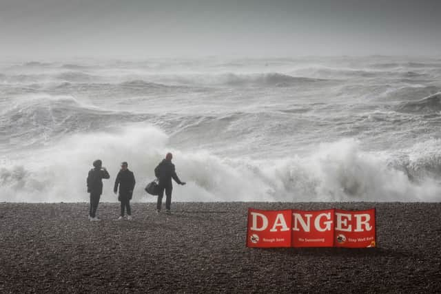
Storm Franklin is the third storm to hit the UK in recent days, following on from the chaos caused by Storm Dudley and Storm Eunice.
The worst of Storm Franklin should have passed by the end of today, Monday 21 February.
Advertisement
Hide AdAdvertisement
Hide AdThe Met Office’s weather warning currently in place - a yellow warning of wind covering Northern Ireland, the far west of Scotland, Wales, and the entirety of England excluding the north-east - is expected to end at 1pm on Monday 21 February.
An amber warning previously in place for Northern Ireland expired at 7am.

You can track the storm for yourself using some very handy online tools. We’ve rounded up some of the best here.
Storm Franklin’s highest gust of 87mph was recorded at the Needles on the Isle of Wight on Sunday (20 February) evening, followed by current gusts of 79mph on a mountaintop in Wales.
Advertisement
Hide AdAdvertisement
Hide Ad“It’s still pretty strong out there and it will continue to be strong over the next few hours,” Mr Dewhurst told the PA news agency.
When will Storm Gladys hit?
According to the list of storm names released by the Met Office, the next storm on the cards for the UK is set to be Storm Gladys.
While the worst of Storm Franklin should be over by the end of the day, the Met Office weather forecast predicts that we’re still in for rain and wind.
On Tuesday, we should expect a “and of cloud and rain, locally heavy at first in the north, clearing to sunshine and scattered showers. These wintry and locally heavy in the north. Remaining rather windy”.
Advertisement
Hide AdAdvertisement
Hide AdThe outlook for Wednesday to Friday also states: “Wednesday mainly dry south and east; elsewhere, heavy rain followed by wintry showers. Thursday cold with blustery sleet/snow showers, sunny spells between. Friday fine with some sunshine and lighter winds.”
If any of these weather systems gets to a point where the Met Office issues a weather warning, then it will be named Storm Gladys.
A message from the editor:Thank you for reading. NationalWorld is a new national news brand, produced by a team of journalists, editors, video producers and designers who live and work across the UK. Find out more about who’s who in the team, and our editorial values. We want to start a community among our readers, so please follow us on Facebook, Twitter and Instagram, and keep the conversation going. You can also sign up to our newsletters and get a curated selection of our best reads to your inbox every day.
Comment Guidelines
National World encourages reader discussion on our stories. User feedback, insights and back-and-forth exchanges add a rich layer of context to reporting. Please review our Community Guidelines before commenting.