Thames Water live sewage map: how to find out if sewage is being discharged into lakes and rivers near you

and live on Freeview channel 276
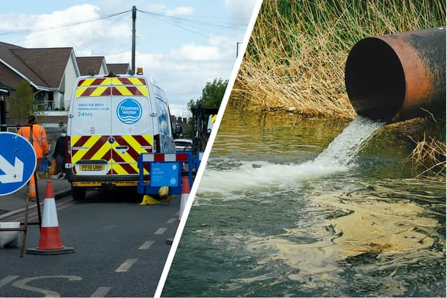
Thames Water has launched an interactive digital map identifying sewage discharges as they take place, after revelations surfaced last year around the levels of sewage is being dumped into Britain’s rivers and seas.
A report from Surfers Against Sewage (SAS), published in December 2022, found that water companies are discharging sewage even during warm and dry weather, which is not permitted under the Environment Agency rules. The group also published its own interactive map of sewage spills across the UK.
Advertisement
Hide AdAdvertisement
Hide AdWhile data from the water companies themselves showed that in 2021 they discharged raw sewage via storm overflows into rivers 372,533 times, over 2.75 million hours.
Environmental groups such as The Rivers Trust, Fish Legal and SAS, have now forced Thames Water, the UK’s largest water company, to publicly release information on when sewage is being discharged.
Michelle Walker, technical director at The Rivers Trust, told NationalWorld that the group welcomes Thames Water “taking this step towards full transparency” and the data is “crucial for swimmers, paddlers, anglers and others who are using the river so they can make decisions on when and where it is safe to enter the water.”

What does Thames Water’s new interactive map show?
Thames Water’s map shows information about its Combined Sewer Overflows (CSOs), which are supposed to act as emergency valves during periods of “intense rainfall”. They enable water companies to discharge millions of litres of untreated sewage and wastewater into rivers and onto beaches - which they claim would otherwise overwhelm the sewerage system and flood houses.
Advertisement
Hide AdAdvertisement
Hide AdThanks to the new interactive map the market town of Fairford, in the Cotswold hills, is now known for its continuous raw sewage overflow.
As of Thursday morning (26 January) the storm overflow from the town’s sewage works had been discharging diluted untreated sewage into the River Coln for 39 hours 45 minutes.
Do other water companies have live sewage maps?
Southern Water also publishes data on sewage released into waterways, but Thames Water is the first company to provide information on inland waterways being subjected to raw sewage discharges.
A Thames Water spokesperson said: “Taking action to improve the health of rivers is a key focus for us, but we also need to explain what is happening, and why. After a successful trial in the Oxford area, we have decided to provide close to real-time information about storm discharges from all of our 468 permitted locations.
Advertisement
Hide AdAdvertisement
Hide Ad“This is a key part of our River Health Action Plan to radically improve both performance and transparency in order to protect and improve the environment. We are the first company to provide these alerts for inland waters and this ‘near real-time’ data is available to customers as a map on our website.
“We want to lead the way with this transparent approach to data and the alerts will be available through an open data platform for third parties, such as swimming and environmental groups, to use.”
Southern Water has released a Beachbuoy pollution alert map for the public. The water company told NationalWorld it has updated and improved the map “to provide customers and stakeholders with an accurate picture of any likely impacts on bathing waters.”
Southern Water added: “Transparency is very important to us and we are working hard to further improve this tool as quickly as we can, and this will involve the inclusion of data from inland water courses.”
Advertisement
Hide AdAdvertisement
Hide AdHowever, environment groups are calling on other water companies to follow in the footsteps of Thames Water.
‘We hope other water companies adopt a common data standard’
Ms Walker, from The Rivers Trust, said: “Thames Water are publishing the data in an open format which will allow others to embed the data in their own maps and apps, which is also welcome, because open data is proven to foster innovation. We hope that other water companies will adopt a common open data standard to make it easy to combine the data into national maps and apps.”
She added: “Of course, this is only part of the sorry picture of pollution entering our rivers – we don’t have live warnings about agricultural pollution runoff, or other sources of sewage such as misconnected domestic appliances or mis-managed septic tanks, so we still urge river users to assess the risks carefully before entering the water.”
Penelope Gane, Head of Practice at Fish Legal, told NationalWorld the group expects other water companies to follow suit: “Although it may create a PR nightmare for them, they are required to do so by law.”
Advertisement
Hide AdAdvertisement
Hide AdMs Gane cited Fish Legal’s landmark ruling in 2015 which made water companies in England and Wales become ‘public authorities’ for the purposes of the Environmental Information Regulations. Therefore they are now under a legal duty to disclose environmental information that they hold from the public.
Ms Gane added: “What that means in practice is that privatised water companies should, by law, be progressively making this type of environmental information available and easily accessible to the public.”
Comment Guidelines
National World encourages reader discussion on our stories. User feedback, insights and back-and-forth exchanges add a rich layer of context to reporting. Please review our Community Guidelines before commenting.