Heatwave threshold exceeded across UK as sweltering 28C highs forecast to stay

and live on Freeview channel 276
A swathe of the UK has exceeded the threshold for a heatwave as dry conditions are forecast to stay this week with temperatures reaching up to 28C.
Regions from the North West to the South East of England experienced highs above the threshold for more than three consecutive days as temperatures soared to the highest level so far this year on Saturday (10 June), reaching 32.2C in Chertsey, Surrey.
Advertisement
Hide AdAdvertisement
Hide AdPorthmadog, north west Wales, saw Tuesday’s highest temperature, at 30.8C.
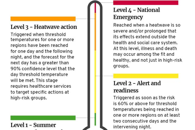
According to the Met Office, a heatwave is defined as three consecutive days with daily maximum temperatures meeting or exceeding the heatwave temperature threshold. The threshold varies in each county.
Met Office spokesman Stephen Dixon said the rest of the week will be hotter than average for the time of year but that the extreme heat may “drop slightly in coming days” meaning the heatwave criteria may not continue to be hit.
He told the PA news agency: “London might not meet heatwave criteria, for example, but there’s a good deal of dry, fine, sunny weather to be had this week with temperatures remaining well above average.
Advertisement
Hide AdAdvertisement
Hide Ad“Into the weekend there should be a fair amount of dry weather, with temperatures remaining warm for many, although also humid and warm overnight.”


Meanwhile, there could be more rain and thunder later in the week following a torrent of thunderstorms that struck several regions. On Sunday afternoon (11 June) the Parklife festival in Manchester had to be briefly halted due to a thunderstorm.
Mr Dixon said on Thursday (15 June) “there is a chance of thunder moving into western areas of Northern Ireland and possibly moving further east into parts of Wales” with a “risk of showers” persisting into Friday (16 June).
But still temperatures will remain high as the Met Office has forecast mid-to-high 20s for much of England over the next few days and London is expected to reach a high of 28C on Wednesday (14 June).
Advertisement
Hide AdAdvertisement
Hide AdOn Wednesday afternoon the mercury could also push 28C in Cardiff while temperatures are expected to be slightly cooler across Scotland, Ireland and Northern Ireland.
In its outlook from Friday (16 June) to Sunday (18 June) the Met Office said weather conditions will remain “mostly settled” though there will be “some showers in the west on Friday.”
The forecaster added that it will turn “more humid with an increasing chance of thunderstorms on Saturday and Sunday.”
Comment Guidelines
National World encourages reader discussion on our stories. User feedback, insights and back-and-forth exchanges add a rich layer of context to reporting. Please review our Community Guidelines before commenting.