Storm Otto 2023: weather warning explained - where in UK will be hit, what has Met Office said?

and live on Freeview channel 276
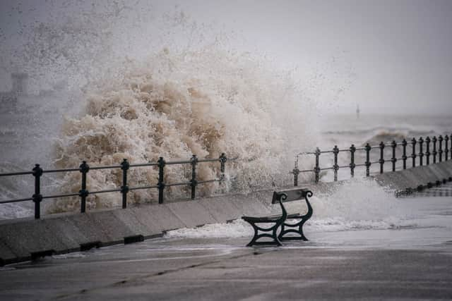
Storm Otto caused disruption across the UK as it moves across the country on Friday (17 Feb), leaving thousands of homes without power. The storm, the first to be named this winter, has been labelled Otto by the Danish Meteorological Institute (DMI) and is expected to cause issues for travellers.
Denmark is expected to bear the brunt of the storm on Friday afternoon, leading the Danes to name the system, which has now been adopted by the Met Office in line with the international storm-naming arrangements.
Advertisement
Hide AdAdvertisement
Hide AdOtto is the first named storm to directly impact the UK this storm-naming season, which began in September.
This is everything you need to know.
What weather warnings are in place?
Yellow weather warnings for wind have been issued for the whole of Scotland and a stretch of north and north-east England running from Sheffield to the Scottish border.
The detailed warning for Scotland explains that residents could expect:
- Possibilities of injuries and danger to life from flying debris, large waves and beach material being thrown onto sea fronts, coastal roads and properties
- Some damage to buildings, such as tiles blown from roofs
- Road, rail, air and ferry services may be affected, with longer journey times and cancellations possible
- Some roads and bridges being closed
- Power cuts, with the potential to affect other services, such as mobile phone coverage

The warning for Scotland runs from 3am to 3pm Friday and the north-east England warning is from 5am to 2pm.
Advertisement
Hide AdAdvertisement
Hide AdMet Office chief meteorologist Andy Page said: “Storm Otto will bring high winds and rain to the UK, with some northern parts of Scotland and the north-east of England likely to get the strongest gusts of wind, possibly in excess of 75mph. Warnings have been issued and could be updated as Storm Otto develops.
“There’s a chance of travel disruption and high-sided vehicles could be particularly prone to disrupted plans in this set-up.
“There’s associated rain with Storm Otto, with 40-50mm of rain likely to fall over parts of western Scotland.”
Additional yellow weather warnings for snow and ice have also been issued across Friday and Saturday.
What are travel companies saying?
Advertisement
Hide AdAdvertisement
Hide AdTransPennine Express has warned customers to check their route before they travel, adding that trains between Berwick-upon-Tweed and Edinburgh will move at reduced speeds in response to the weather.
In a thread of tweets, Scotrail said on Twitter: “Due to the wet and windy weather caused by #StormOtto, we have had to implement an Emergency Timetable/Speed Restrictions for many areas across the country. For the latest service information please refer to our app or Journey Check, it has the same info that we do.
“Services across much of the country are likely to be delayed and may have to be cancelled/revised.”

Leeds Bradford Airport remained open but a spokesperson said the weather had caused disruption to flight schedules.
Advertisement
Hide AdAdvertisement
Hide Ad“We currently remain open but are experiencing some delays and disruptions to flights. We’d recommend passengers check with their airlines and on our website for live updates,” the spokesperson said.
London North Eastern Railway (LNER) said a number of services had been cancelled, and train firm Northern said a tree was blocking the line between Harrogate and Knaresborough, affecting a range of services.
The company also said: “Due to an object being caught on the overhead electric wires at Wakefield Westgate, all lines are blocked. Train services running through this station will be cancelled, delayed by up to 25 minutes or diverted.”
There were also reports of trees blocking some roads in Harrogate and Leeds.
Have homes lost power?
Advertisement
Hide AdAdvertisement
Hide AdAbout 19,000 homes were left without power over 143 incidents, Northern Powergrid said. More than 11,000 are said to have since had supplies restored.
A Northern Powergrid spokesperson said: “At present, for customers impacted, we’re hopeful that the majority of customers will have their power restored today, with the potential of a small number that may run into Saturday.”
Energy company SSEN said that as of 11am on Friday, 30,000 properties were without power, and it warned it may take more than 48 hours to fully restore supplies.
It said it has so far restored power to more than 10,000 properties.
Advertisement
Hide AdAdvertisement
Hide AdThe network has a significant number of faults on its high voltage network as a result of fallen trees, branches and windblown debris, SSEN said.
Mark Rough, operations director at SSEN Distribution, said: “Following the significant and continued impact of Storm Otto on our electricity distribution network in the north of Scotland, our engineers have been out since first light this morning to restore power to our customers.

“Despite the widespread nature of the storm, coupled with ongoing adverse weather conditions and challenges with access, our teams have made good progress restoring power to homes impacted. With wind speeds expected to subside from around midday, we expect to make significant progress throughout the course of today.
“However, due to the extent of damage, some customers are likely to remain off supply for over 48 hours. We’re working closely with our resilience partners to support local efforts as our teams work to reconnect supplies across our network area.
Advertisement
Hide AdAdvertisement
Hide Ad“I’d like to reassure our customers we’re doing everything we can to restore power as quickly as possible. I’d encourage anyone who may need additional support to contact our dedicated teams on the power cut helpline, 105.”
Comment Guidelines
National World encourages reader discussion on our stories. User feedback, insights and back-and-forth exchanges add a rich layer of context to reporting. Please review our Community Guidelines before commenting.