UK Weather: Met Office issues yellow weather warnings as 12 hours of rain and 70mph wind set to hit, forecast

and live on Freeview channel 276
Yellow weather warnings for wind and rain have been issued for many parts of the UK on Thursday (February 22), potentially causing travel disruption and power cuts, the Met Office said, as unsettled conditions set to continue in the coming days.
Forecasters warned of wind gusts of up to 70 mph along exposed beaches in southern and eastern England, with the warning in force from 8am to 6pm. There is also the risk of up to 40mm of rain in East Anglia and the southeast of the country, with a warning in effect from 5am to 5pm. Met Office Chief Meteorologist Paul Gundersen said: “After what has been a wet February so far, further rain is on the way on Thursday, accompanied by some gusty winds and potential impacts for those within the warning areas which cover much of southern, central and eastern England.”
Advertisement
Hide AdAdvertisement
Hide Ad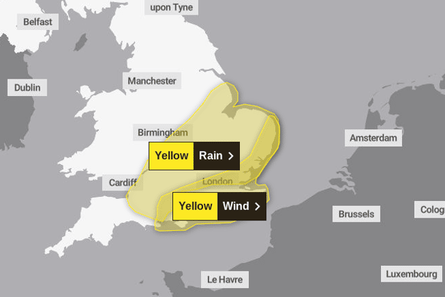

“There’s a small chance that wind gusts could reach 60-70mph, mostly likely on exposed coasts, though more widely we're likely to see a shorter spell of heavy, squally rain with hail and thunder in a few places and gusts to around 50mph. Most places within the warning areas are likely to see 10-15mm of rain, with a chance of 30-40mm in a few places. This is falling on saturated ground, which elevates the chances of flooding and disruption.”
The Met Office said the unsettled conditions will likely continue through the weekend. It said: "Friday will be a breezy day for many, with showers feeding into many areas, though these will generally be more frequent in the west. Temperatures are returning more towards average for the time of year compared to the recent mild weather.
"Showers should reduce through Saturday, giving most areas a drier spell of weather. Further persistent rain and locally strong winds are likely to move into some southern areas on Sunday, though those further north are likely to see drier conditions."
5-day weather forecast
Wednesday (February 21)
A wet and windy morning. Then gradually becoming drier and brighter from the north and west as the day progresses, with some sunshine developing. However some parts of southern and southeast England will remain cloudy and damp all day. Overnight, further rain and drizzle across southern counties of England and Wales. A band of heavy, squally rain moving across northwestern parts overnight. Mild in the southeast, colder further north.
Advertisement
Hide AdAdvertisement
Hide AdThursday (February 22)
The band of heavy squally rain will continue to move southeastwards, followed by sunny spells and blustery showers. Feeling colder for many, with showers falling as snow over northern hills.
Sunny spells and blustery showers on Friday and Saturday, falling as snow over northern hills. perhaps turning wetter and winder across southern parts heading into Sunday. Near average temperatures.
Comment Guidelines
National World encourages reader discussion on our stories. User feedback, insights and back-and-forth exchanges add a rich layer of context to reporting. Please review our Community Guidelines before commenting.