Weather warning UK: Met Office forecast, where are flood warnings in place, how much rain is expected?
and live on Freeview channel 276
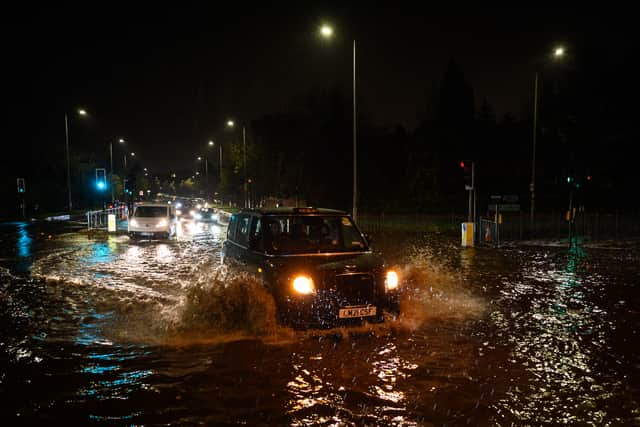
Britons are set to be lashed with rain over the weekend as temperatures turn colder.
A thunderstorm warning was in place until the early hours of Friday in the south-east of England and flood warnings remain in force for parts of the country. More downpours are expected throughout Saturday.
Advertisement
Hide AdAdvertisement
Hide AdThe Met Office website said: “Rain spreading east on Saturday, after a chilly start in the east. Rain then lingering across southeast England on Sunday; sunshine and showers, locally heavy, elsewhere.”
It comes after parts of London endured more than half a month’s worth of rainfall in one night as people woke on Thursday to downpours, flooded roads and transport problems. A total of 64mm of rain fell in Horsmonden in Tunbridge Wells, Kent, while some places saw more than 50mm of rain in a 24-hour period, the Met Office said.
In the South East of England, some train and underground services were hit by cancellations and delays. Here is all you need to know about the flood warnings:
Where are flood warnings in place?
Red flood warnings - meaning flooding is expected - have been issued for three parts of England by the government. A flood warning means you need to act. You should:
- move vehicles to higher ground if it’s safe to do so
- move family and pets to safety
- move important items upstairs or to a safe place in your property, starting with cherished items and valuables, then furniture and furnishings
- turn off gas, electricity and water supplies if it’s safe to do so; never touch an electrical switch if you’re standing in water
- if you have property protection products such as flood barriers, or air brick covers, use them now
- keep track of the latest flood risk situation

Alfriston
Flooding is expected
Advertisement
Hide AdAdvertisement
Hide AdOn the government’s website, the warning states: “The Cuckmere River in Alfriston is still very high, but now slowly falling. Flooding will continue to affect The Old Clergy House, Deans Place Hotel, North Street, Willows Car Park and River Lane. A dry day on Friday has allowed river levels to continue to fall.
“However, flood impacts and high river levels in Alfriston could remain until next week. Friday (4 November) evening should remain dry and only a small amount of rain is forecast for Saturday (5 November). However, 25mm of rain forecast for Sunday could cause some further flooding.
“Please remain prepared for the possibility of further flooding on Sunday (6 November). Please plan to avoid driving through routes vulnerable to flooding, including North Street, Alfriston and keep flood protection products installed, if you have them. We continue to monitor the levels and forecast.”
Barcombe Mills
Flooding is expected
The warning on the government’s website reads: “The River Ouse remains high through Barcombe, following Thursday’s heavy rain. River levels are continuing to fall, but flood impacts may continue to affect a small number of properties in Barcombe Mills and at the Anchor Inn.
Advertisement
Hide AdAdvertisement
Hide Ad“Barcombe Mills Road and Anchor Lane may still be impassable. Flood water may continue to be extensive through fields.
“The river will return to a more normal level by Saturday (5 November). However, 25mm of rain forecast for Sunday, could cause some further flooding.
“Please plan to avoid driving through routes vulnerable to flooding, including Barcombe Mills Road. Flood protection products are recommended to be installed in Barcombe, if you have them. We are operating our structures in Barcombe to help keep the river flowing freely and reduce flood risk.”
Mock Bridge, near Shermanbury on the River Adur
Flooding is expected
The government’s website has issued the following warning: “The River Adur is high, but now slowly falling, following Thursday’s heavy rain. Flooding will continue to affect the A281 at Mock Bridge, near Shermanbury, until Saturday (5 November). As well as there being extensive water in fields, flooding will also affect properties near Mock Bridge and their gardens.
Advertisement
Hide AdAdvertisement
Hide Ad“Friday evening and early Saturday morning should remain dry, which should allow river levels to fall significantly. However, a small amount of rain is predicted for Saturday, and further heavy rain (25mm) is currently forecast for Sunday (6 November), which could cause further flooding.
“Please remain prepared for the possibility of flooding on Sunday. Some roads, including the A281 at Mock Bridge, may become impassable. Please plan to avoid driving through routes vulnerable to flooding. We continue to monitor the levels and forecast.”
Where are flood alerts in place?
The yellow ‘flooding is possible’ alert has been issued for 16 locations across England. A flood alert means you need to prepare: flooding is possible. If you haven’t already done so, you should:
- sign up for flood warnings
- keep up to date with the latest flood risk situation - call Floodline on 0345 988 1188 or follow @EnvAgency and #floodaware on Twitter for the latest flood updates
- have a bag ready with vital items like insurance documents and medications in case you need to leave your home
- check you know how to turn off your gas, electricity and water mains supplies
- plan how you’ll move family and pets to safety
Chertsey Bourne
Flooding is possible
“Property flooding is not currently expected. River levels remain high on the Chertsey Bourne as a result of persistent recent heavy rain.”
Cuckmere River
Flooding is possible
Advertisement
Hide AdAdvertisement
Hide Ad“The Cuckmere River in Alfriston is still very high, but now slowly falling. Flooding will continue to affect The Old Clergy House, Deans Place Hotel, North Street, Willows Car Park and River Lane. The Cuckmere and Bull Rivers through Hellingly are still higher than normal, but significantly lower than Thursday’s peak. Minor flood impacts will continue to affect gardens of properties on Station Road, Church Lane and Church Road, Hellingly.”
Eastern Yar
Flooding is possible
“The water level in the Eastern Yar remains high but is now falling at Alverstone and Sandown. Residual flood impacts are expected to be affecting land, footpaths and cycle tracks. Minor impact flooding will continue to affect Golf Links Road and Moreton Common Road.”
Lower River Medway
Flooding is possible
“This Flood Alert remains in force following heavy rain on Thursday morning and again on Thursday night. The Medway remains relatively high at all locations between Yalding and Allington Lock, including Maidstone.”
River Adur East Branch
Flooding is possible
“The River Adur is high, but now slowly falling, following Thursday’s heavy rain. Flooding will continue to affect the A281 at Mock Bridge, near Shermanbury until Saturday. As well as there being extensive water in fields, flooding will also affect properties near Mock Bridge and their gardens.”
River Blackwater and The Cove Brook
Flooding is possible
Advertisement
Hide AdAdvertisement
Hide Ad“Property flooding is not currently expected. River levels remain above flood alert threshold on the River Blackwater as a result of the recent heavy rainfall. Therefore, flooding of low lying roads, footpaths and farmland is expected this evening today, especially in the Swallowfield area.”
River Mole and its tributaries from Kinnersley Manor to South Hersham
Flooding is possible
“River levels remain high in the Leatherhead and Cobham areas. The risk of flooding to roads and low lying land remains for today. Further rainfall is expected today and overnight into Sunday.”
River Rother and its tributaries from Turks Bridge to the Royal Military Canal
Flooding is possible
“Levels are now failing gradually at all locations in the Rother valley with peak conditions experienced late Thursday evening. Nevertheless, levels are still relatively high especially around Etchingham and Robertsbridge and minor flood impacts are still expected.
“The internal flooding of property is not expected. Patchy rain is due on Saturday evening and heavier rainfall is due on Sunday and so this Flood Alert will probably be maintained throughout the weekend”
Rivers Eden and Eden Brook
Flooding is possible
Advertisement
Hide AdAdvertisement
Hide Ad“Minor flood impacts are still expected. The internal flooding of property is not expected. Patchy rain is due on Saturday evening and heavier rainfall is due on Sunday and so this Flood Alert will probably be maintained throughout the weekend.”
South East Somerset Rivers, Upper Reaches
Flooding is possible
“Water levels have risen at the Sherborne Lake river gauge as a result of the recent heavy rainfall. Consequently, there remains a low risk of flooding to low-lying land and roads. Locations most vulnerable to flooding are the Sparkford to Weston Bampfylde road and Deep Ford Lane, Chetnole. Further rainfall is forecast early morning.”
Upper Ouse
Flooding is possible
“River levels along the Ouse are now falling steadily following a dry Friday evening. Minor flood impacts will continue at Fletching Mill Bridge, Sharpsbridge, and areas of Barcombe Mills but should reduce as Saturday continues. 10mm of rain is forecast across Saturday which should see limited impacts on river fall. However, localised heavy showers of 25mm are forecast for Sunday which may see river levels rise.”
Upper River Derwent, Stonethwaite Beck and Derwent Water
Flooding is possible
“River and lake levels remain high on the Upper River Derwent, Stonethwaite Beck and Derwent Water due to recent rainfall. Today is forecast to be a showery day and the lake level at the Lodore gauge is expected to keep receding. However the lake will remain high for at least the next few days, with further rain forecast over the next few days.”
Upper River Medway
Flooding is possible
Advertisement
Hide AdAdvertisement
Hide Ad“This Flood Alert remains in force following heavy rain on Thursday morning and again on Thursday night. Levels have returned to normal at Forest Row but remain high at Summerford Bridge, near Withyham and at Colliersland Bridge near Ashurst. Nevertheless, peak conditions were experienced on Friday 4 November 2022 and levels are now steadily dropping in these locations. Minor flood impacts are still expected.”
Comment Guidelines
National World encourages reader discussion on our stories. User feedback, insights and back-and-forth exchanges add a rich layer of context to reporting. Please review our Community Guidelines before commenting.