When does the cold snap end? How long will temperatures stay low UK, when is it likely to get warmer

and live on Freeview channel 276
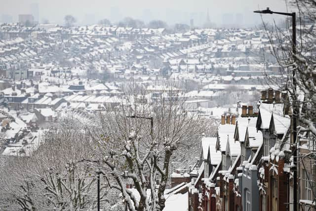
The UK has been experiencing “severe cold weather and icy conditions”, with snow reaching London and the coldest night of the year recorded at -17.3C in Scotland.
The plummeting temperatures have been blamed on an “arctic maritime air mass”, with members of the public being urged to look out for vulnerable friends and family and to ensure they heat their homes to 18C and wear “several layers of clothing” to stay warm.
Advertisement
Hide AdAdvertisement
Hide AdA Level 3 Cold Weather Alert -issued by the UK Health Security Agency (UKHSA) has been extended to cover all of England until Friday 16 December.
The Met Office have predicted that the cold temperatures will remain in place until the weekend, with further risks of sleet and snow across northern and eastern areas.
So when will the cold snap end? Here’s everything we know so far.
When will the cold snap end?
The Met Office have predicted that the cold conditions will start to ease after the weekend, and that the cold conditions will lose “dominance over the UK’s weather patterns”.

Advertisement
Hide AdAdvertisement
Hide AdSpeaking about what we can expect, Met Office Chief Forecaster Paul Gundersen explained: “Over the last week, the UK has been held in a northerly airflow bringing cold, sometimes Arctic air, to the UK. We will still have this northerly influence to our weather patterns until the weekend, but then the cold conditions will lose exclusive dominance over the UK’s weather patterns and we will move into a regime where relatively mild and relatively cold conditions will vie for supremacy.”
Gunderson added: “We can expect changeable conditions with colder and milder air not too far away from our shores, but it does seem that the Atlantic ‘has woken up’ compared with recent days and will be a stronger influence, countering any further bouts of extreme cold conditions, although spells of further wintry weather remain possible through the rest of December.”
Why is it so cold?
The plummeting temperatures and wintry conditions have been blamed on an “arctic maritime air mass” that has brought below zero figures and snow to areas across the UK. The air mass has been caused by a high-pressure weather system over Greenland and Iceland that has moved into another high-pressure system over Russia. The cold air that has been caught between them has moved south to the UK.
In response to the freezing temperatures, the UK Health Security Agency (UKHSA) issued a Level 3 Cold Weather Alert covering all of England from 7 December until Friday 16 December.
How long will temperatures stay this low?
Advertisement
Hide AdAdvertisement
Hide AdTemperatures are predicted to stay chilly until the Atlantic air mass returns at the end of the weekend. Further snowfall is possibly on the horizon until the Arctic air mass passes, with wintry showers predicted in areas on the north and east, along with overnight frosts and the possibility of temperatures as low as -10C in rural Scotland.
Met Office Deputy Chief Forecaster Steven Keates explained: “The boundary between the two air masses will create a window for snowfall over the weekend. This is likely to be transient in nature as the mild wet air from the west will ‘bump’ into the colder air, before displacing it further east. This potential spell of snow will lead to some temporary disruption before the snow quickly turns to rain.”
When is it likely to get warmer?
The Met Office have predicted that most parts of the UK will begin to become milder by the “late end of the weekend”. However the outlook is still uncertain with temperatures expected to turn cooler again in the run up to Christmas.
The Met Office weather forecast for the UK from Sunday 18 December to Tuesday 27 December predicts: “Most parts becoming much milder than of late by the end of the weekend. Into the start of next week, turning cooler again with showers, heavy at times, across the north and northwest and some rain in the far south. Drier, brighter conditions likely in between. The remainder of the period carries some uncertainty, but less cold and more changeable conditions seem more likely, especially in southern areas. Meanwhile, further north, we stand a greater chance of colder weather along with some wintry showers being more prevalent.”
Comment Guidelines
National World encourages reader discussion on our stories. User feedback, insights and back-and-forth exchanges add a rich layer of context to reporting. Please review our Community Guidelines before commenting.