Will there be thunderstorms today? Met Office yellow weather warning explained - where in UK will get thunder

and live on Freeview channel 276
On Wednesday (20 July) morning, thunder and lightning battered South west and south Wales, bringing in heavy rainfall and thunderstorms.
Residents in Cornwall and the Isles of Scilly were “relieved” to see the sky “go black and the rain start pouring” in the early hours of Tuesday morning, according to Lucy McRobert, communications manager for the Isles of Scilly Wildlife Trust.
Advertisement
Hide AdAdvertisement
Hide AdThe Met Office has issued a yellow weather warning as it forecasts heavy showers and thunderstorms during Wednesday (20 July) afternoon and evening.
But which areas will be affected, and is thunder normal after a heatwave?
Where are there thunder warnings in the UK?
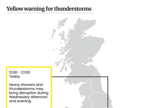

A yellow weather warning for heavy showers and thunderstorms is in place across south east England and parts of the Midlands between 1pm and 9pm on Wednesday 20 July.
The forecast covers large parts of England, including cities such as Nottingham, Peterborough, Norwich, Oxford, London and parts of Birmingham.
Advertisement
Hide AdAdvertisement
Hide AdThis warning comes after many areas of the UK felt the effects of record-breaking temperatures in a two-day heatwave that caused devastation to some parts of England.
This may disrupt a few services to public transport and cause road closures:
- Where flooding or lightning strikes occur, there is a chance of delays and some cancellations to train and bus services.
- Spray and sudden flooding could lead to difficult driving conditions and some road closures.
- There is a slight chance that power cuts could occur and other services to some homes and businesses could be lost.
You can track where thunderstorms are happening live on netweather.tv.
Is thunder and lightning normal after a heatwave?
In July 2021, London faced flash floods following a heatwave, which caused many homes, roads and tube stations to be flooded and closed.
Advertisement
Hide AdAdvertisement
Hide AdAmber warnings for thunderstorms were issued for the weekend (25 July 2021) by the Met Office, as meteorologists warned that southern and central parts of England and Wales would see flash flooding.
Last year, Met Office meteorologist Steven Keates said storms were being caused by a “convergence” of air currents, due to warmth on the earth’s surface from the recent heatwave rising into cooler air in the atmosphere.
Climate scientist, Henry Mance, tweeted: “almost exactly a year ago, London was hit by flash floods.
“the Met Office is giving us warnings about heavy rain after a heatwave. this is how climate change works”.
What is the weather forecast for the rest of the week?
Advertisement
Hide AdAdvertisement
Hide AdThis is the Met Office weather forecast for the rest of the week:
Wednesday 20 July
Cloudier than recently with some sunny spells. Less hot across the UK but still warm. Very warm or hot in parts of the east and southeast. Some heavy showers developing over central England.
Tonight (20 July)
Showers gradually dying out over England, lingering longest over Lincolnshire and Norfolk. Fairly cloudy central and eastern parts. Much cooler than recent nights but still warm in east and southeast.
Thursday (21 July)
Rather cloudy for many with sunny spells. A little light rain or drizzle possible during the morning central and eastern parts. Feeling warm for many but much cooler than recently.
Outlook for Friday to Sunday (22 - 24 July):
Sunshine and scattered showers on Friday. Rain and wind spreading to the north through the weekend. Mostly dry with lighter winds in the south and becoming warmer.
Comment Guidelines
National World encourages reader discussion on our stories. User feedback, insights and back-and-forth exchanges add a rich layer of context to reporting. Please review our Community Guidelines before commenting.