Blizzard weather warning UK: what does Met Office weather alert mean and dangers to be aware of as snow hits

and live on Freeview channel 276
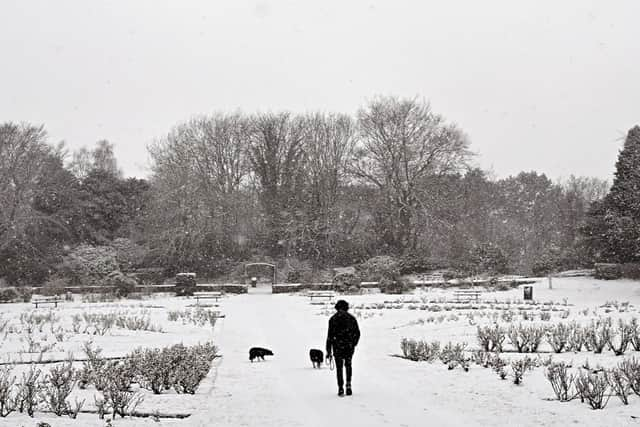
The Met Office has issued amber warnings for “blizzard conditions” after the UK recorded the coldest March temperature in more than a decade.
Snowstorms predicted to cause “significant disruption” will affect large areas of England, Wales and Northern Ireland. This comes after the lowest temperature of 2023 was recorded overnight (9 March) at Altnaharra in the Highlands, with temperatures dipping to a chilling -16C.
Advertisement
Hide AdAdvertisement
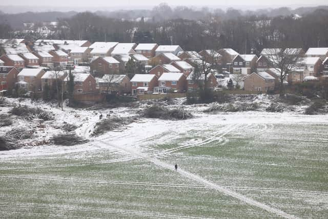
Hide AdA level 3 cold weather alert has also been issued by the UK Health Security Agency for England, with communities being urged to check in on anyone who “may be more vulnerable to the cold weather”. The RAC have reported 50% more breakdowns than usual in the worst affected areas, with some drivers stuck in the snow in parts of South Yorkshire and Wales. They’ve advised drivers to think “carefully before setting out” on the roads.
So what does the Met Office weather warning mean and what dangers should you be aware of? Here’s everything you need to know.
Where are the Met Office blizzard warnings?
The Met Office have issued weather warnings for snow and ice across the UK. Three amber warnings are currently in place until Friday (10 March) from the south of the Peak District up to the North Pennines, northern and eastern areas of Wales and east of Northern Ireland, with “heavy snow” predicted to cause “significant disruption”. There are also additional yellow weather warnings across Northern Ireland, eastern Scotland, Wales, central England and East Anglia.
What does the Met Office alert mean?
The Met Office warnings means that many areas across the UK will be on alert for snow or ice. Dropping temperatures also pose a risk, with the lowest temperature for 2023 recorded last night at Altnaharra in the Highlands, with temperatures dipping to a chilling -16C.

Advertisement
Hide AdAdvertisement
Hide AdMet Office Chief Meteorologist, Jason Kelly explained that regions across the UK could see “blizzard conditions”. He said: “The boundary between milder and colder air is gradually moving north, with some heavy and persistent snow likely at times on the northern edge of this boundary. Snow has already settled quite widely in centrals parts of the UK and further accumulations are likely even to lower levels with disruption most likely for those within the amber warning areas.”
Kelly continued: “With some strong winds accompanying these snow showers, blizzard conditions are likely for a time in northern England and Wales, as well as parts of Northern Ireland. Ice will be a continuing hazard for many in the forecast period, with very low overnight temperatures likely to exacerbate continued likely travel disruption.”
As well as the amber weather warning, there is also a yellow warning for snow and ice covering north Wales, northern and central England, Northern Ireland and southern Scotland, which is set to last through to Friday.
What dangers should I be aware of?
With dropping temperatures and snow and ice warnings across many regions in the UK, there are dangers that members of the public should be aware of. The three amber weather warnings issued by the Met Office highlight possible travel disruption, power cuts and the possibility that some rural communities could become cut off due to the weather.
Advertisement
Hide AdAdvertisement
Hide AdThe RAC have already reported 50% more breakdowns in the worst affected areas and have recommended drivers think “carefully before setting out today”. RAC Breakdown spokesperson Rod Dennis said: “We’re seeing up to 50% more breakdowns in the worst affected areas today compared to normal, with some drivers already stuck in the snow in some parts of South Yorkshire and Wales. Rural routes through central and northern England covered by the Met Office’s amber weather warning are also starting to get difficult to negotiate, and these are areas drivers should avoid if they can.”
He continued: “Given the weather, we recommend thinking carefully before setting out today as, with more snow forecast, things are likely to get worse on the roads before they get better. These aren’t conditions anyone wants to be caught out in, so those who have to drive need to be confident on potentially slippery surfaces, have ensured their vehicles are up to the task, and are carrying an emergency breakdown kit so they can stay warm and communicate easily should they get stuck or break down.”
A level 3 cold weather alert has also been issued by the UK Health Security Agency for England, with communities being urged to check in on anyone who “may be more vulnerable to the cold weather,” and to ensure homes are heated to at “least 18C”.
Dr Agostinho Sousa, Head of Extreme Events and Health Protection at the UK Health Security Agency, said: “During periods like this, it is important to check in on family, friends and relatives who may be more vulnerable to the cold weather, as it can have a serious impact on health. If you have a pre-existing medical condition or are over the age of 65, it is important to try and heat your home to at least 18C if you can.’’
Comment Guidelines
National World encourages reader discussion on our stories. User feedback, insights and back-and-forth exchanges add a rich layer of context to reporting. Please review our Community Guidelines before commenting.