Flash floods UK: where is at risk this week of flooding, Met Office forecast, how much heavy rain is expected?

and live on Freeview channel 276
The UK has been experiencing some extreme weather over these last few weeks - and now after days of intense heat people are being warned to brace themselves for flash flooding.
Just days after an official drought was declared due to a lack of rainfall, the Met Office has now issued a yellow thunderstorm warning and experts have also said there could be flash floods across the UK too.
Advertisement
Hide AdAdvertisement
Hide AdSo, just where is at risk of flash flooding, how much rain is expected, and just what causes flash floods?
Here’s everything you need to know.

Where in the UK is at risk of flooding?
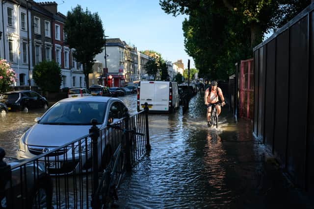
The whole of the UK is currently at risk of experiencing flash flooding, however, it is more likely in some areas than others.
Flash flooding is most common in areas where rivers are narrow and steep as this provides the perfect platform for the water to flow more quickly.
Anywhere with hard surfaces, such as built-up urban areas, that don’t let the water drain into the ground are also more prone to flash flooding as local drainage systems can be overwhelmed due to surface overflow.
Advertisement
Hide AdAdvertisement
Hide AdAfter a drought, the number of areas with hard surfaces increases significantly because the ground is so dry, leading to the increased possibility of flash flooding.
How much rain is expected in the UK this week?
Some places could see about 50mm of rain falling in a three-hour period in the north.
Meanwhile, some areas further south may get around 30mm of rain in a three-hour period.
The Met Office provides a daily rainfall forecast which provides hourly updates on where rain is expected today and tomorrow.
Advertisement
Hide AdAdvertisement
Hide AdThere’s also a rainfall map showing you where in the country it will rain today.
The map can also be used to determine whether the rain today or tomorrow will be persistent or more intermittent.
You can view the Met Office rainfall radar map on the official Met Office website.
What is the Met Office weather forecast?
Today, Wednesday 17 August, it will be heavy showers and thunderstorms affecting southern and southeast England, though some warm sunny spells are also likely.
Advertisement
Hide AdAdvertisement
Hide AdIt will be cooler and cloudier for some central and eastern parts, with rain dying out, and mostly dry and fine in the northwest.
It’s expected to rain as far south as London and Cardiff, and also as far north as Edinburgh and Inverness, as well as hitting Belfast.
Experts also say that showers may merge into longer spells of heavy rain at times.
The Met Office forecast states that this evening there will be thunderstorms in the southeast which will slowly dye out.
Advertisement
Hide AdAdvertisement
Hide AdMost parts of the country will be dry with clear spells, turning chilly in places. Cloud and rain will reach the far northwest later.
The weather forecast for the rest of the week, through to Friday 19 August, is similar.
Met Office experts are predicting heavy showers and thunderstorms across the south today, and drier conditions further north.
Most places are expected to be dry on Thursday 18 August, but rain will move in from the northwest, clearing southeast on Friday 19 August to sunny spells.
What has the Met Office said?
Advertisement
Hide AdAdvertisement
Hide AdDan Stroud, a meteorologist at the Met Office, said the drastic change in weather from the recent prolonged periods of heat and dry days and nights is due to an alteration in the air pressure.
He said: "We’ve had a number of days now where we’ve had clear, strong, clear skies and strong sunshine which has heated up the ground.
"We’ve had high pressure dominating, now we’re having low pressure dominate, so the air is becoming more unstable.
“As we’ve had some very high ground temperatures, it doesn’t actually take too much for the air to become even more unstable and for thundery showers to develop quickly."
Advertisement
Hide AdAdvertisement
Hide AdHe also explained why the rain may lead to flash floods - and actually do little to help with the drought.
"It will help a little but to be honest really, it’s almost the wrong sort of rain.
"What we’re likely to see is some heavy, intense downpours. With the ground baked so dry, it’s very difficult for the ground to actually absorb the water very quickly.
"So what tends to happen in these circumstances is the water runs off and we can potentially get some surface run-off issues, so some flash floods."
What causes flash floods?
Advertisement
Hide AdAdvertisement
Hide AdFlash flooding occurs when rail falls so fast that the underlying ground cannot absorb enough of it.
Thunderstorms are likely to be the biggest cause of flash floods due to the severity and frequency of rainfall which does not give the ground the chance to soak in the water and drain it away fast enough.
This leads to roads becoming like rivers, and there is often very little time between the rain falling and the flash flooding occurring.
Due to the warm weather which has been widespread across the country over the last few days, every area is at risk of thunderstorms - and therefore flash flooding.
Comment Guidelines
National World encourages reader discussion on our stories. User feedback, insights and back-and-forth exchanges add a rich layer of context to reporting. Please review our Community Guidelines before commenting.