
Met Office issues new yellow warning for thunderstorms with hail and lightening across UK locations

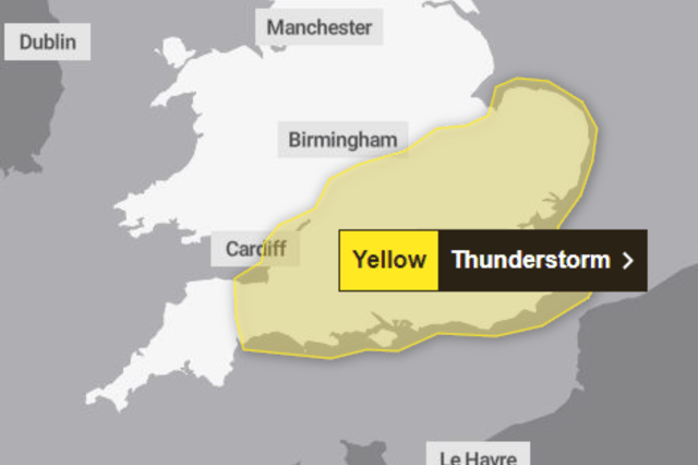

The Met Office has updated its yellow weather warning for thunderstorms, with rain, hail and lightning set to hit the country.
Heavy rain and strong winds have already been felt in some areas after ex-Hurricane Kirk brought stormy conditions to the UK. Swathes of the country have been hit by unsettled weather, but a new yellow warning has been introduced for a large part of southern England.
The yellow warning has been in place since 10am today (October 8) and is in place until 3am on Wednesday, October 9. The warning covers the the southern coast as far east as Exeter, and stretches north toward Peterborough and Gloucester.
The Met Office said in its weather warning: “Showers and thunderstorms will [move] north and east across southern Britain through the afternoon and well into the evening, before gradually clearing from the west. Whilst some areas will miss these, where they develop 20-30 mm of rain within 2-3 hours, with a small chance that a few places could receive 40-50 mm over a longer period - particularly across the southeast of the area this evening.
“Hail and lightning will be additional hazards, with a risk of temporary hail accumulations in places. In addition, heavy showers and thunderstorms will be associated with strong and gusty winds in the south of the warning area at times with 40 mph gusts possible.
A previous yellow rain warning was in place for parts of Northern Ireland until 5pm. Meteorologist Liam Eslick said: “We are looking to see quite a lot of rainfall with 20mm-30mm in two to three hours but there could be some very heavy bursts with 40mm-50mm falling over a longer period of time.
“We are expecting to see not just rain, we are expecting some hail and quite a lot of thunder, a lot of these showers could turn thundery as they combine together and become larger systems. So we are expecting thundery outbreaks and quite gusty conditions, it’s a pretty hefty system across the south.”