Snow update: Met Office confirms snow and ice is on its way as yellow weather warnings issued across UK
and live on Freeview channel 276
Parts of the UK are bracing for a cold snap as the Met Office issued new snow and ice warnings.
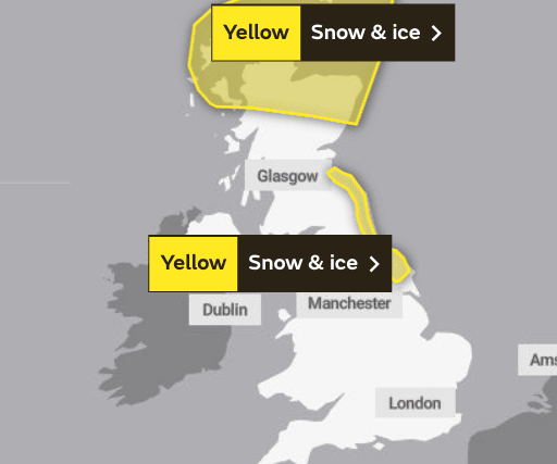
Snow and ice are expected to arrive in the UK on Tuesday evening (November 28), with warnings sticking around until Thursday morning (November 30). It comes after warning of a so-called 'snow-bomb' later this week, with forecasts showing that the end of the month into December will bring wintry weather.
Advertisement
Hide AdAdvertisement
Hide AdThe yellow snow and ice warning, beginning at 5pm on Tuesday, will cover northern Scotland, including Aberdeen and Inverness, as well as parts of eastern Scotland and north-east England, including Newcastle-upon-Tyne. This warning will expire at 11am.


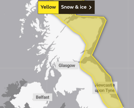
A second yellow warning for snow and ice is in place from 5pm on Wednesday November 29 in the same areas, but this time continuously up the eastern coast of the UK, covering areas such as Edinburgh and Dundee as well. This will expire at 11am on Thursday 30 November.
it is believed that snow is possible in those places covered by the yellow weather warning, with up to 2cm possible overnight from Wednesday into Thursday. This could rise to 5cm on higher ground.


David Oliver, a Met Office deputy chief meteorologist, said: "The weather models are highlighting several possible solutions from very wet to mainly dry, with a mainly dry picture the most probable outcome at present. However, some models include the prospect of an area of low pressure developing and moving in from the south or south-west.
Advertisement
Hide AdAdvertisement
Hide Ad“If this solution proves to be correct, we could see an area of warmer and moisture-laden air ‘bumping’ into the cold air further north. Along the boundary of the two air masses lies a zone across southern and central Britain where snowfall could develop fairly widely. Snow in any affected area is unlikely to be anything more than transient and short-lived, but it could lead to small totals and some disruption over a few hours before melting.”
Comment Guidelines
National World encourages reader discussion on our stories. User feedback, insights and back-and-forth exchanges add a rich layer of context to reporting. Please review our Community Guidelines before commenting.
