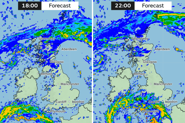
Storm Ciarán: weather tracker shows trail of storm as downpour hits areas of the UK
and live on Freeview channel 276
Storm Ciarán has made landfall in the UK, bringing with it downpours and high winds - and it's only set to get worse.
Various weather warnings, both yellow and amber, for rain and wind are in place over the next few days as the stormy conditions look set to batter the country. Amber warnings for wind are in place for the entire southern coast of England and Pembrokeshire in Wales on Thursday (2 November), while yellow rain warnings are in place in the same areas, as well as parts of Scotland from Wednesday onewards.
Advertisement
Hide AdAdvertisement
Hide AdMet Office deputy chief meteorologist Dan Suri said: “Wind and rain warnings associated with Storm Ciaran are in force from Wednesday night onwards into Friday. As well as strong winds, this deep low pressure system will bring heavy rain to many parts of the UK. Much of southern England and south Wales, as well as parts of north Wales, northeast England, southeast Scotland and perhaps the east of Northern Ireland look to see the wettest conditions between Wednesday evening and Friday morning.”
According to the Met Office's rainfall map tracker, from 10am on Wednesday morning, much of Scotland will be covered by rain as the storm condition begin to hit the UK. Throughout the day, the downpour will remain mostly in Scotland, travelling upwards towards the north-west.


However, later on Wednesday evening, from around 6pm onwards, the eye of the storm will creep closer to the England's south-west coast. Conditions will worsen throughout the evening and overnight Areas such as Plymouth and Exeter could see between 8mm and 16mm per hour, while the heavy rain moves north to Hereford and much of Wales.


Overnight, the entire southern coast, including Southampton and Brighton will be drenched by rain, slowly moving up the country to Nottingham, Manchester and York. At around 6am on Thursday morning, the south-west coast of England, the south-west coast of Wales and areas in the north-east of England - including Newcastle and Whitby - will see the heaviest downpours in the country.
Advertisement
Hide AdAdvertisement
Hide AdLoading....
When will Storm Ciarán pass?
The eye of the storm will slowly move into the North Sea as Thursday progresses. The poor conditions will still be sticking around, particularly in north-east and northern Scotland.
Weather warnings in relation to Storm Ciarán are expected to expire on Friday. However, heavy rain is still forecast on Saturday, moving from the south-west at 3am, moving northwards up the country until around midday, when the worst of the rain is expected to finally let up.
Comment Guidelines
National World encourages reader discussion on our stories. User feedback, insights and back-and-forth exchanges add a rich layer of context to reporting. Please review our Community Guidelines before commenting.
