
Will it rain today? Met Office latest as Storm Bert disruption continues - full list of flood warnings

Storm Bert will continue to bring disruption into Monday after torrential downpours caused “devastating” flooding over the weekend.
Hundreds of homes were left underwater, roads were turned into rivers and winds of up to 82mph were recorded across parts of the UK.
The last of the Met Office’s rain warnings ended at 11.59pm on Sunday but strong winds persist and rain from high ground will reach rivers, which could disrupt clean-up efforts. More than 200 flood alerts remain in place for England and Wales and travel issues are set to continue into the new week.
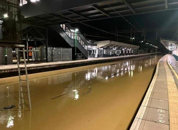

South Wales will be counting the cost of the storm after a major incident was declared in the Rhondda Cynon Taf region on Sunday amid fears of a more significant impact than during Storm Dennis in 2020. Between 200 and 300 properties in the area were affected by flooding, with local leaders expressing surprise at the extent of the rainfall.
Welsh First Minister Eluned Morgan said it had been “a really difficult weekend”.
She said: “I think this is the second time that many of those have suffered as a result of the storm. There’s been huge investments since the last storm hit, so we’ve managed to protect lots more properties than last time. But obviously this is absolutely devastating just before Christmas for those people who have been impacted.”
At a press conference in Pontypridd on Sunday afternoon, Rhondda Cynon Taf County Borough Council leader Andrew Morgan said he was “amazed” that only a yellow weather warning had been issued by the Met Office.
“On Saturday we were preparing for the possibility of an amber warning,” he said. “It didn’t come but we took the decision ourselves to step up our resources and have depots open and crews in.
“I am surprised there wasn’t a red warning issued. During Storm Dennis we saw an amber warning in advance and a red warning issued in the early hours. I do think that will need to be reviewed shortly.”
In North Wales, a body was found in the search for 75-year-old Brian Perry, who went missing while walking his dog during the storm on Saturday near the Afon Conwy river.
Another man, who was in his 80s, died after his car entered water at a ford on Cockhill Lane in Foulridge, Colne, Lancashire, on Saturday afternoon. It was unclear if the incident was directly related to Storm Bert.
The Met Office forecast that rain in the south-east of England will clear on Monday but blustery showers could stick around for the north-west.
Rail passengers have been urged not to travel between Broxbourne, Hertfordshire, and Stansted Airport after multiple fallen trees damaged the electrical overhead wires. Major disruption is expected until 2pm on Monday.
Southern, which runs rail services across the south-east of England, said some services on Monday will be cancelled or revised because of forecast severe weather, including on its London network and the West Coastway between Havant and Southampton. Services across other rail companies could start later than normal as tracks which were flooded or hit by fallen trees are inspected.
On Sunday night, some major roads were closed due to the ongoing impacts of flooding. The Fire Service and South Gloucestershire Council have reported flooding across several areas of the region.
Flooded roadways include the A431 around Bath Road in Swineford, Shire Way Yate and adjacent roads, St Johns Way in Chipping Sodbury and adjacent roads, Stidcot Lane in Tytherington, Perrinpitt Lane in Bristol, and Old Gloucester Road in Winterbourne.
The M32 in Bristol was closed northbound between J1 near Hambrook and the M4 J19, and the A49 in Shropshire and Herefordshire was closed in both directions between Ludlow and Holmer.
In Northampton, police advised motorists to avoid the following Storm Bert-related road closures on Monday: Andrew’s Road and its surrounding areas, St James’ Park Road along Victoria Park, Dallington close to the brook, London Road/Bridge Street in Far Cotton, and Bedford Road.
Also in Northampton, London Northwestern Railway reports that no rail services will operate to and from Northampton Station. There is also no road access to the station, so rail replacement buses will be unable to run.
Thameslink reports a points failure has occurred between Herne Hill and Tulse Hill with all lines in this area disrupted with delays and possible diversions or route alterations possible on Monday.
Some 350,000 homes in England lost power during the storm, though most have since been reconnected.
More than 300 flights set to depart from UK airports were cancelled during Storm Bert, aviation analytics firm Cirium said.
Heathrow Airport was worst affected, with crosswinds of up to 40mph causing disruption to departures and arrivals on Sunday.
Simon Brown, services director at the Met Office, said: “Our thoughts are with those who are currently affected with the impacts caused by Storm Bert in South Wales, as well as the rest of the country. As always with a named storm, a full assessment of the forecast and warning strategy will take place with our partners.
“But this assessment is carried out post-event, therefore I would expect this to take place over the coming days. Storm Bert was well forecast, 48 hours in advance, with a number of warnings in place ahead of the system reaching the UK.
“We work closely with partners to assess the potential risks of extreme weather and the warnings covering Wales highlighted the potential for homes and businesses to flood with fast-flowing or deep floodwater possible, causing a danger to life.”
On Sunday, large rainfall accumulations were seen, with some places experiencing an excess of 130mm in the last 24 hours. In some more exposed areas, wind gusts of over 75 miles per hour were experienced.
Flood warnings - full list
One severe flood warning - danger to life
- River Nene at Billing Aquadrome and nearby business parks
159 flood warnings - flooding is expected
- Areas near the Wootton Brook in the Collingtree, Merefield and Shelfleys parts of Northampton
- Bourne Brook at Hints and Drayton Manor Park
- Brimfield Brook at Orleton and Brimfield
- Bristol Avon at Bath, riverside properties
- Bristol Avon (lower) from Twerton to Bristol
- Bristol Avon (mid) at Melksham
- Bristol Avon (middle) at Bradford on Avon
- Bristol Avon (middle) from Melksham to Bathford, not including Bradford on Avon
- Bristol Avon (upper) at Chippenham, other properties set back from the river
- Bristol Avon (upper) at Chippenham, riverside properties
- Bristol Avon (upper) from Chippenham to Melksham
- Bristol Avon (upper) from Malmesbury to Chippenham
- Bristol Frome from downstream of Nibley to Stapleton
- Bugbrooke and Nether Heyford including areas near the upper River Nene
- Clay Coton Brook at Clay Coton and Yelvertoft Brook at Yelvertoft
- Cogenhoe Mill Caravan Site
- Dauntsey Brook at Dauntsey, Old Sodom Lane and The Green areas
- Doniford Stream in the Sampford Mill Farm area
- English River Dee at Farndon
- Ginge Brook between Steventon and Sutton Courtenay, including Milton and Drayton Mill areas
- Great Easton Brook in Great Easton
- Harpers Brook in Brigstock and Sudborough
- Isolated properties and mills near the upper River Nene
- Isolated properties and villages near the River Nene from Wellingborough to Thrapston
- Isolated properties near the River Nene from Cogenhoe to Great Doddington
- Kyre Brook at Tenbury Wells
- Landford to Wade Bridge on the River Blackwater
- Lower Frome from Dorchester to East Stoke
- Lower Frome from East Stoke to Wareham
- Lower Stour from Sturminster Marshall to Christchurch
- Low lying areas close to the River Great Ouse and River Ouzel at Newport Pagnell
- Low lying areas close to the River Great Ouse at Fulwell, Radclive and Buckingham
- Middle Hampshire Avon at Britford, Salisbury
- Middle Hampshire Avon from Salisbury to Ringwood
- Middle Stour from Hammoon to Sturminster Marshall
- Properties closest to the River Kennet at the Burghfield, Southcote, Coley and Holybrook areas
- River Aller
- River Alne at Chapel Lane and Church Lane in Aston Cantlow and Great Alne
- River Arrow and River Alne at Alcester and Oversley Mill
- River Arrow at Eardisland
- River Ashburn at Ashburton
- River Asker from Askerswell to Bradpole
- River Avon at Strensham and Bredon
- River Avon at Wyre Piddle
- River Axe (Lower) from Axminster to Axmouth
- River Axe (Upper) from Winsham to Axminster, including Chard Junction and Weycroft
- River Biss upstream and downstream of Trowbridge
- River Bovey at Bovey Tracey and Heathfield
- River Bride from Long Bredy to Burton Bradstock
- River Brue and Glastonbury Millstream from Lovington to Highbridge, low lying properties
- River Cherwell from below Banbury to just above Upper Heyford
- River Cherwell from Charwelton to above Banbury
- River Cherwell from Lower Heyford down to Cherwell Bridge
- River Chew from Stanton Drew to the Bristol Avon at Keynsham
- River Clyst from Broadclyst to Clyst St. Mary
- River Culm (Lower) from Cullompton to Stoke Canon, including Hele
- River Dart from Buckfastleigh to Totnes, including Staverton
- River Dene at Walton
- River Dove at Dovefields Crossing and Saltbrook Cottage
- River Ebble from Ebbesbourne to Nunton
- River Evenlode at Milton under Wychwood, Shipton under Wychwood and Ascott under Wychwood
- River Frome at Bishops Frome
- River Frome at Fromebridge and Eastington
- River Great Ouse and Padbury Brook at Thornton, Beachampton and Passenham
- River Great Ouse at Brackley
- River Harbourne at Crowdy Mill, Beenleigh, Bow and Tuckenhay
- River Ise in Clipston
- River Ise in Geddington
- River Isle at Ashford Mill and Ilford Bridges
- River Isle at Ilminster
- River Isle from Chard Reservoir to Hambridge not including Ilminster
- River Ivel at Langford
- River Jordan in Braybrooke and Little Bowden
- River Key from the Bentham area to Cricklade including Purton Stoke
- River Leam at Eathorpe, Hunningham and Offchurch
- River Lemon from Bickington to Newton Abbot
- River Lew at Gribbleford Bridge and Hatherleigh
- River Lugg at Bodenham
- River Lugg at Leominster
- River Lyd at Lydney
- River Lyd from Sydenham to Lifton
- River Nadder, Tisbury to West Harnham
- River Nene and tributaries in Northampton, including low-lying areas adjacent to the river
- River Nene in Kislingbury
- River Nene in Weedon
- River Nene upstream of the Northampton Washlands and properties near the Old River Nene in Abington
- River Okement at Brightley, Jacobstowe and Monkokehampton
- River Ouse at Naburn Lock
- River Ouse at York - riverside properties
- River Ouse at York - St George's Field and Queen's Staith
- River Parrett (upper) from South Perrott to Thorney
- River Ray from the Heath Bridge area to and including the Otmoor Basin
- River Rother at Beighton
- River Severn at Apperley and The Leigh
- River Severn at Bushley
- River Severn at Court Meadow, Kempsey and Callow End
- River Severn at Pentre
- River Severn at Severn Ham, Tewkesbury
- River Severn at Tewkesbury
- River Severn at the Showground and The Quarry, Shrewsbury
- River Severn in South Worcester
- Rivers Stour and Iwerne at Stourpaine
- River Stour at Mitford Bridge, Shipston on Stour and Tredington
- River Stour from Halford to Clifford Chambers
- River Tamar from Greystone Bridge to Cotehele excluding Calstock
- River Tame at Hamstead
- River Taw (Middle) from Taw Bridge to Newnham Bridge
- River Teign at Newton Abbot Racecourse
- River Teign (Lower) from Chudleigh to Kingsteignton
- River Teign (Upper) from Clifford Bridge to Chudleigh
- River Teme at Bransford
- River Teme at Eardiston
- River Teme at Knightwick, Doddenham and Broadwas
- River Teme at Leigh
- River Teme at Leintwardine and Walford
- River Teme at Shelsley Walsh and Clifton Upon Teme
- River Teme at Stanford Bridge
- River Teme at Tenbury Wells and Burford
- River Tone from Bathpool to Ham including Ruishton and Creech St Michael, riverside properties
- River Torridge (Lower) from Dolton to Bideford, including Taddiport and Weare Giffard
- River Tove and Silverstone Brook at Towcester
- River Tove at Towcester and Cosgrove
- River Ure at Boroughbridge Camping and Caravanning Site
- River Vyrnwy at Maesbrook
- River Vyrnwy at Melverley
- River Weaver at Acton Bridge and Weaverham
- River Weaver at Nantwich, Lakeside View
- River Weaver at Nantwich Riverside
- River Weaver at Northwich Marina
- River Weaver at Shrewbridge Lodge
- River Wreake for mills at Hoby, Thrussington and Ratcliffe
- River Wriggle at Chetnole
- River Wye at Rotherwas, Hereford
- River Wye from Hay to Hereford
- River Wye from Hereford to Ross-On-Wye
- River Wye in North Hereford
- River Wye in South Hereford
- River Yarty from Yarcombe to Axminster
- River Yeo at Mudford
- River Yeo from Sherborne to Yeovil
- Semington Brook from upper reaches to Semington
- Sherston Avon at Malmesbury
- Sherston Avon from Luckington to Malmesbury
- Shill Brook at Carterton and Bampton
- Somerset Frome from Frome to Freshford
- Sor Brook at Bodicote and Adderbury and The Bloxham Brook
- South Marston Brook at South Marston
- Swill Brook below Oaksey
- Tetbury Avon at Malmesbury
- Upper Frome at Maiden Newton
- Upper Frome from Maiden Newton to Dorchester
- Upper Hampshire Avon, Upavon to Amesbury
- Washford River, riverside properties from Kingsbridge to Lower Roadwater
- Water Eaton Brook at Water Eaton
- Weaver Navigation at Winsford
- Wendlebury village on the Wendlebury Brook
- Wider area at risk from the River Great Ouse at Fulwell, Radclive and Buckingham
- Willow Brook in Corby
- Willow Brook in Weldon and Kings Cliffe